Find A Trail. Start Your Search Here:

Thursday, April 25, 2013

CSI: Flagstaff hiking trail


UPDATE: May 2013, a suspect has been apprehended. The hunt is on for the person who started this month's Fisher Fire and the forest service is asking for your help.  ....watch out for that backpack and hiking stick, though.
...nope, it's not this guy.


From: "Smith, Brady -FS" <bradysmith@FS.FED.US>
Date: April 25, 2013 11:25:07 AM PDT
To: <USDA-FS-NEWS@NEWSBOX.USDA.GOV>
Subject: SOUTHWESTERN-NEWS-RELEASE: Coconino National Forest
NEWS RELEASE                   
U.S. Dept. of Agriculture
U.S. Forest Service
Coconino National Forest
www.fs.usda.gov/coconino                                        
For Immediate Release
Apr. 25, 2013
Public Affairs Contacts:
Brady Smith, Coconino National Forest, 928-527-3490
Brienne Magee, Flagstaff Ranger District, 928-527-8290
Forest Service law enforcement seeking Fisher Fire person of interest
Flagstaff, Ariz. – Law enforcement with the Coconino National Forest are seeking a person of interest regarding the human-caused Fisher Fire which began on April 13 about four miles southeast of Flagstaff near Fisher Point and grew to approximately 35 acres.
The person is described as a white male who frequents the area wearing a brown coat and black T-shirt with a black hat. This person may have a backpack and use a walking stick.
Anyone with information regarding this individual or has seen someone matching this description in that area please contact law enforcement at 928-527-3552.
###

Tuesday, April 23, 2013

KACHINA WETLANDS via HIGHLANDS TRAIL


KACHINA WETLANDS via HIGHLANDS TRAIL
Flagstaff
Kachina Wetlands: April 2013

Hidden on a high Flagstaff mesa just about a mile off I17 is a walk able, 70-acre waterfowl wonderland.  The Kachina Wetlands is a collection of 8 shallow ponds constructed to manage treated effluent water. The project, which began in 1988 with the cooperation of various agencies including NAU, AZ Game & Fish and Coconino County, has auxiliary goals to improve wildlife habitat and foster native vegetation. Although some of the ponds are not operational right now, the site is still prime real estate for winged beasts.   Thick growths of cattails and other aquatic plants coupled with  mid-pond islands provide safe havens from marauding elk and hungry forest critters for the hundreds of species of birds and waterfowl that frequent the area.  The marshy pools are aflutter with grebes, mallards, coots, sandpipers, nighthawks, woodpeckers, swallows, chickadees, jays, warblers, blackbirds and soaring birds of prey.  Until recently, the only hiking opportunity here was the mile or so of circumference paths.  That all changed when the Highlands Trail-- which connects to Ft Tuthill Park-- was completed in 2009.  Woodsy but unremarkable, the easy, urban-class Highlands Trail stays close to civilization dodging public roads and private properties on its 3.7-mile track from the park to the wetlands. The trail wanders through a checkerboard of pine-oak woodlands (with occasional views of San Francisco Peaks and Mormon Mountain), skirts a few suburban backyards and crosses AZ89A before reaching the wetlands. 


LENGTH: 9.6 miles round trip
RATING: easy
ELEVATION:  6890' - 7040'
BEST SEASON: open year-round, but bird sightings are best spring-fall
DOGS: dogs MUST be on leash and stay out of the wetlands ponds
FACILITIES: restrooms, picnic tables, camping at the park
GETTING THERE:
Fort Tuthill County Park (as described here):
From Phoenix travel north on I17 to exit 337 for AZ89A and "county fairgrounds". At the end of the off ramp, continue straight into Ft. Tuthill Park and follow the main road to the Yavapai Ramada parking lot.
Kachina Wetlands (direct access):
From Phoenix take I17 north to exit 333 for Kachina Village.  Go left off the access road, drive under the freeway and take the first right on Tovar Trail. Follow this road 1.5 mile to the corner of Tovar Trail and Lohali Trail, park on the right and pass through the gate to the wetlands.
Yellow-headed blackbird

HIKE DIRECTIONS:
From the Ft Tuthill Yavapai parking lot, hike south on the road on the west side of the amphitheater to where Soldiers Trail (marked by green lathe-style signs) crosses.  Head west (go right) and follow Soldiers Trail roughly .30 mile to a signed, but un-named junction.  This is the access path for Highlands Trail.  Turn left here and within 0.2 mile you'll come to the north end of the loop portion of Highlands Trail.  Go either way and continue 1 or 1.3 mile to AZ89A.  Cross the road and continue 2.5 miles on Highlands to Kachina Wetlands.  There are several trails circling the ponds.  When done exploring, return the way you came or take the opposite leg of the Highlands loop back to the parking area. NOTE: Ft Tuthill Park has an "official" trailhead serving all its trails.  If you begin there, add another mile to the overall distance shown here.
Peaks view along Highlands Trail

INFO & MAP:
Fort Tuthill County Park, Coconino County Parks & Recreation: 928-679-8000

Kachina Wetlands:
NAU management plan:
Northern Arizona Audubon bird checklist:

MORE PHOTOS:

Friday, April 19, 2013

Hike around an iconic Sedona rock formation


LOWER CHIMNEY ROCK & SUMMIT ROUTE
Sedona
Chimney Rock

Next to Cathedral Rock, Chimney Rock is one of the most iconic sandstone formations in Sedona.  Visible from just about everywhere in downtown Sedona, this singular, russet pillar (actually three clustered spires) stands sentry beneath the cream-colored behemoth of 6355' Thunder Mountain (aka Capitol Butte). Soaring to 4995', this natural sculpture cuts an impressive silhouette because of how it's isolated along a limestone ridge.  However, even with two of Red Rock Country's most recognizable geological formations looming 
Little Sugarloaf
above the trail, it's the "baby sister"---4872' Little Sugarloaf---that gets all the attention on this hike because the route makes a wide loop around the layered cone of this mini-mount.  A wooden "summit" sign marks the start of an optional spur path to the top.  The worthwhile diversion is short but mostly on slick rock, so proceed with care.  From the summit, views stretch all the way to Prescott, Jerome and Flagstaff. 

LENGTH:  2.9 miles
Lower Chimney Rock Loop: 1.5-mile loop
Summit Route: 0.7 mile one-way
RATING: easy-moderate
ELEVATION: 4550' - 4600' or 4870' with summit
FEE: A Red Rock Pass is required.  $5 daily fee.
HOURS: dawn to dusk daily
Butterfly on cliff fendlerbush, April 2013

GETTING THERE:
From Phoenix, travel north on I17 to exit 298for AZ179, Sedona-Oak Creek.  Head west (go left) and continue to the "Y" intersection of AZ179 and AZ89A in Sedona.  Veer west (left) through the traffic circle and continue 3.2 miles on AZ89A to Dry Creek Road.  Turn right and go 0.4 mile to Thunder Mountain Road, turn right and go 0.5 mile to the Thunder Mountain trailhead on the left.
INFO:  City of Sedona
MORE PHOTOS:

Thursday, April 18, 2013

Urban exercise hike


ALVORD LAKE
Phoenix

It was one of those Saturdays.  You know, those sacrificial weekend days given to yard work. While out  rushing around to the various plant nurseries in the area, I came across Cesar Chavez Park.  Even though I've known about it for years, I never really considered it a hiking destination.  However, when curiosity got the better of me, I made a quick detour between chores and discovered a very pleasant walking path and an unexpected, welcome leg stretch. The park is packed with ammenities like swing sets for the kids and is also part of the Arizona Game & Fish Urban Fishing Program.  The easy, paved walking path circles the 25-acre lake and has nice views of South Mountain, the Estrella Mountains and  plenty of water fowl.


LENGTH: 1.1 mile loop
RATING: easy, paved, barrier-free
ELEVATION: 1012'
HOURS: 5:30 a.m. - 11:00 p.m.
FACILITIES: picnic tables, shade ramadas, boat ramp, fishing, playground, restrooms.

GETTING THERE:
From central Phoenix, go south to Baseline Road, go west to 35th Ave  turn south and follow the signs to Cesar Chavez Park at 7858 S. 35th Ave.
INFO:
City of Phoenix Parks & Recreation, 602-262-6111

Arizona Game & Fish Urban Fishing Program

Tuesday, April 16, 2013

An educational “add-on” hike


ELDEN PUEBLO
Flagstaff
Add caption

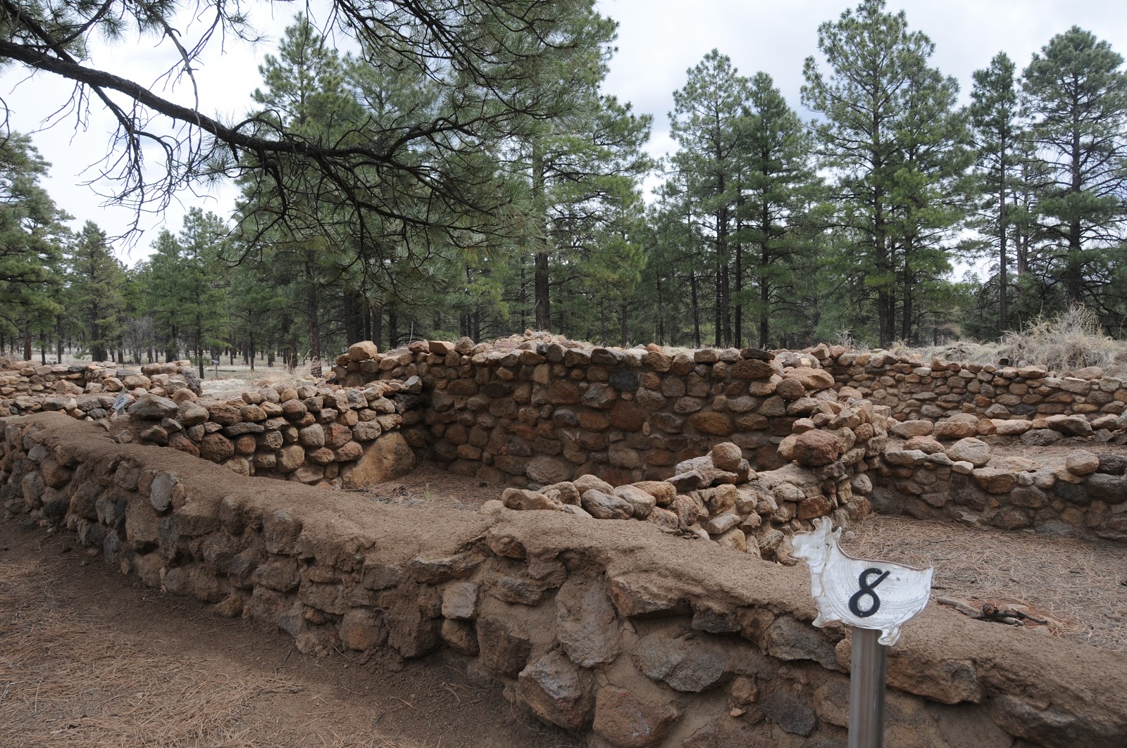
Once the meeting place of the Sinagua people, this archeological site located a few yards from busy AZ89 is now a major stop off for tourists, students and hikers alike. Brochures available at the trailhead correspond with numbered stops along the wide, flat gravel trail.  Each of the 15 sites tells a tale of life and culture in the village which at its high point was home to as many as 200 people.   Although short, plan on spending at least an hour to observe and read about the building techniques, life ways and archeological research.  A visit to this interesting roadside attraction is a good way to wind down after a longer hike in the area.

LENGTH: 0.1 mile loop
NEARBY HIKING TRAILS:
Old Caves Crater,
Elden Environmental Study Area,
Pipeline Trail,
Sunset Crater National Monument,
O'Leary Peak
RATING: easy, barrier-free (gravel)
ELEVATION: 6940'
HOURS: open year-round
FEES: none
GETTING THERE:
From Phoenix, go north on I17 to the I40 interchange in Flagstaff.  Head east (right, toward Albuquerque) and connect with AZ89 north.  Follow AZ89 to milepost 420 and start watching for the "Elden Pueblo" sign, which is just south of Townsend-Winona Road. Turn left and park in the gravel lot. 
INFO: Flagstaff Ranger District, Coconino National Forest
Elden Pueblo Program Manager: 928-527-3452

MORE PHOTOS:

Fisher Fire is 100% contained.


....close shave.  No word yet as to when Sandy's Canyon Trail will re-open.

From: "Magee, Brienne U -FS" <bmagee@FS.FED.US>
Date: April 16, 2013 3:04:11 PM PDT
To: <USDA-FS-NEWS@NEWSBOX.USDA.GOV>
Subject: SOUTHWESTERN-NEWS-RELEASE: Coconino National Forest
April 16 Update:
The Fisher Fire is 100% contained and 35 acres (slightly smaller size due to more accurate mapping last night). Cause is still under investigation. This was human caused, as there was not any lightning in the area, but specific cause has yet to be determined.

Brienne Magee
Public Affairs Specialist
Flagstaff Ranger District, Coconino NF
5075 N Hwy 89
Flagstaff AZ 86004
o: 928-527-8290

Monday, April 15, 2013

Fisher Fire update

UPDATE: 4-17-2013
Although the Fisher Fire has been declared "100% contained" as of yesterday afternoon, there's still no word as to when the Sandy's Canyon and AZT segment near Fisher Point will be re-opened.  Here's a link to the fire map:
http://azdailysun.com/map-of-fisher-fire/pdf_547c7218-a62e-11e2-bdbe-0019bb2963f4.html

Hikers, because Sandy's Canyon trail is one of my favorites,I've been following this fire very closely and will post forest service press releases as they send them to me.  Looks like fire fighters are making progress.....

Sandy's Canyon: fire was approximately here...

From: "Magee, Brienne U -FS" <bmagee@FS.FED.US>
Date: April 15, 2013 9:15:54 AM PDT
To: <USDA-FS-NEWS@NEWSBOX.USDA.GOV>
Subject: SOUTHWESTERN-NEWS-RELEASE: Coconino National Forest
April 15, 2013

           
Fisher Fire update, 8:30 a.m.

Flagstaff, Ariz. – The Fisher Fire crept and smoldered last night, but did not grow in size. Firefighters have a line around the fire and will continue to strengthen them today. Fire managers want to be sure lines hold through the high winds, however, before they declare an increase in containment.


Size: Approximately 40 acres
Containment: 50%
Location: near Fisher Point approximately four miles south of Flagstaff and two miles northeast of Lake Mary Road and the Canyon Vista Campground.
Date Reported: Saturday, April 13 at approximately 4pm
Cause: Human caused, under investigation
Resources: Approximately 100 personnel including four hotshot crews (Flagstaff Hotshots, Prescott Hotshots, Pleasant Valley Hotshots, and Blue Ridge Hotshots), engines, water tenders, a dozer and several overhead
Closures: The Sandy’s Canyon Trail and Arizona Trail at Fisher Point have been temporarily closed.

Smoke may be visible from the Flagstaff area and will drift to the east; expect smoke to be noticeable in Walnut Canyon, I-40, and the Continental Country Club area.

###

Sunday, April 14, 2013

Fire closes Sandy's Canyon & AZT near Fisher Point

FISHER FIRE UPDATE
Hi Hikers, well, we have our first trail-impacting forest fire of the season.  The human-caused Fisher Fire was reported yesterday.  Here's the forest service press release


Fisher Point

April 14, 2013          
Fisher Fire update, 10:30 a.m.
Flagstaff, Ariz.The Fisher Fire, south of Flagstaff, burned actively throughout the night. This morning it is approximately 40 acres. Winds are expected to continue today, increasing this afternoon.

Fisher Fire Facts
Date Reported:
Saturday, April 13 at approximately 4pm

Size: Approximately 40 acres

Location: near Fisher Point approximately four miles south of Flagstaff and two miles northeast of Lake Mary Road and the Canyon Vista Campground.

Cause: Human caused, under investigation

Resources: Approximately 80 personnel including three hotshot crews, three engines, two water tenders, a dozer and several overhead

Closures: The Sandy’s Canyon Trail and Arizona Trail at Fisher Point have been temporarily closed.

Smoke will be visible from the Flagstaff area and will drift to the east; expect smoke to be noticeable in Walnut Canyon, I-40, and the Continental Country Club area.
 

###

Make friends and influence tourists on AZ trails


BROKEN ARROW & SUBMARINE ROCK TRAILS
Sedona
Chicken Point


Blame the looming federal tax due date or the start of another baseball season, but this past Saturday, I found myself without a hiking partner.  We all know the mantra---"never hike alone", still, I simply HAD to hit the trails.  The solution---head out to a very popular trail and tell someone of my plans.  As the month of April is prime tourist season for Sedona, picking a busy route wasn’t too tough. Close to town and easy-to-find, Broken Arrow Trail is a perfect choice for tourists and locals looking for an easy trek with lots of company.  The trail parallels rugged 4x4 Broken Arrow Road, which is used by Sedona jeep tour companies and off-road enthusiasts alike, so be prepared to see them cross your path.  At the trailhead, I met two very nice guys visiting from the east coast who asked if they could tag along with me as they didn’t “get” the whole basket carin system of route-finding and worried about straying off on one of the unofficial bike routes that cross the main trail.  Actually, save for one confusing junction, the route is easy to follow, but I was happy to have someone to chat with during the hike. (We also “adopted” two ladies from New York for the return trip). In addition to its proximity to town, this hike comes highly recommended due to its ample supply of things to see along the way.  At the 0.6-mile point, there’s Devils Dining Room (not to be confused with Devil’s Kitchen) an impressive sinkhole inhabited by bats.  Next up is an optional side trip to Submarine Rock, a long sandstone formation a couple hundred feet below the main trail.  Soon, the route becomes a series of slick rock passages, each more scenic than the one before, until, just over that last weather worn red rock mound, the incredible vistas of Chicken Point cause a frenzy of “here-take-my-picture” moments.  From here, the trail connects with Chapel and eventually Little Horse trails if you want to add distance or do a car shuttle. However, we returned the way we came as my visiting travel companions had exhausted their camera batteries and were suffering from blissful visual overload.

 
Scene from the trail


LENGTH:  4.8 miles (including 1.4 mile side trip to Submarine Rock)
RATING:  easy
ELEVATION:  4280’ – 4630’
FEE: a Red Rock Pass is required. Daily, $5 daily, $15 weekly, $20 annually.

Slick rock ledge with Submarine Rock on left
GETTING THERE:
From Phoenix, travel north on I17 to exit 298 for Sedona-Oak Creek AZ179.  Head west (go left) on AZ179 and continue to the Morgan Road traffic circle at milepost 312.  Turn right onto Morgan Road and drive 0.5 mile to the trailhead on the left.  Roads are paved up to the last 0.1 mile which is rough dirt, but passable by carefully driven sedans. 
INFO:  Red Rock Ranger District, Coconino National Forest
http://www.fs.usda.gov/recarea/coconino/recreation/hiking/recarea/?recid=55250&actid=50 
MORE PHOTOS:

Thursday, April 11, 2013

Arizona Trail upcoming events


ARIZONA TRAIL RUNNING & HIKING SERIES
promotional postcard

Here's a fun way to get out and experience our state-spanning Arizona Trail (AZT). This series of 10k to half marathon (13.1) running/hiking events on some of the most scenic AZT passages are designed to build awareness of and generate funds to manage and support the  mission of maintaining this 800-mile National Scenic Trail as a world-class recreation destination. Each event comes complete with refreshments, prizes and an opportunity to socialize with like-minded outdoor enthusiasts. There's a modest registration fee and participants must sign up in advance.

UPCOMING EVENTS:
APRIL 27: Vail
MAY 18: Pine
SEPT 29: Mormon Lake

AZT WEBSITE:

Wednesday, April 10, 2013

Hike in Prescott's granite dells


CONSTELLATION TRAILS
Prescott

Lost Wall trail

Some people believe that good luck will ensue if you can hold your breath while traveling through a tunnel. There's an opportunity to test this theory at the gateway to Prescott's Constellation Trails. Take a deep breath of clean prairie air and--if you're taller than 5'4"---duck down, head through the AZ89 underpass and exhale birth-like in a weathered world of ancient granite dells at the trailhead on the other side.
The crystal-infused granite dells are a wonder and this web of loop paths takes hikers through a beautifully varied terrain in just under 3 miles.  "You-are-here-style" maps are posted at the  trailhead and at every junction throughout the system, making navigation super simple. The most challenging legs are North 40 and Lost Wall---both of which traverse the area's highest, rockiest places. From the bare-rock high points, views of bucolic Williamson Valley frame the distant peaks of Flagstaff and Williams at the edge of the Northern Arizona's Colorado Plateau.  The trails move among juniper- shaded glens and exposed slickrock where white paint dots mark the way. A couple of fun squeezes through stone corridors get hikers up close and personal with bizarre patterns infused within igneous rock. Back at the trailhead, there's a commemorative plaque paying tribute to the Navy crewmen of the Air Force Lockheed C-121G USS Constellation, which crashed here in 1959.   A small pile of wreckage sits nearby. 
passage in the dells


LENGTH: 2.74 miles collective
RATING: easy-moderate
ELEVATION:  5016' - 5229'
FEES: none
DOGS: leashed dogs are allowed
GETTING THERE:
From Phoenix, go north on I17 to the Cordes Junction AZ69 interchange.  Head west toward Prescott on AZ69 and continue through town to the AZ89 junction.  Go north on AZ89--past Watson Lake--to just beyond milepost 318 and turn right at the entrance for Phippen Museum.  Look for the "trailhead parking" area---do not use the museum lot. Trail begins at the gate near AZ89.


View of Williamson Valley from the trails

INFO & MAP:
City of Prescott

MORE PHOTOS:

Monday, April 8, 2013

National search for “Summit Samplers”


$500 TO HIKE?---IT COULD HAPPEN

Arizona's high point Humphreys Peak, 12,633'

Hi Hikers, Did you know that, in addition to their primitive-by-modern-standards climbing gear, Sir Edmund Hillary and Tenzing Norgay carried Grape-Nuts cereal with them on their May 29, 1953 summit of Mt. Everest? It’s true---this iconic breakfast staple has seen the top of the world.
In celebration of the 60th anniversary of this historical achievement, the folks at Post Grape-Nuts Fit have asked me to invite YOU to apply to be part of a commemorative, nationwide event to be held on or around May 29, 2013.  Up to 60 hikers will be selected as “Summit Samplers”.  Each participant will be provided with a packet of goodies and Grape-Nuts samples to hand out while hiking up a local peak (big or small) of their choice.  In addition, “samplers” who complete their journey and send in photos documenting their climb will receive $500!  How’s that for doing what you’d probably do anyway? What have you got to loose---log on to this website to apply.  But hurry, entries are only being accepted through FRIDAY, APRIL 19, 2013.
APPLY NOW:

Friday, April 5, 2013

52 miles of new, local trails set to open in June


BROWN'S RANCH TRAILHEAD UPDATE
McDowell Sonoran Preserve, Scottsdale
UPDATE: June 10, 2013---trailhead is now open to the public. 
Work continues on the much-anticipated JUNE 2013 opening of North Scottsdale's Brown's Ranch trailhead. The McDowell Sonoran Conservancy is still in need of dedicated volunteers to staff and patrol what will undoubtedly be a VERY popular destination. Check out the website below learn how to get involved. The next volunteer orientation is APRIL 13, 2013.
Linda Raish, the Conservancy's Community Development Director has provided the following

The City of Scottsdale expects the following to be ready by June, 2013:
  • Trailhead complete and operational
  • 52 miles of trails operational from the trailhead including trails around Cone Mountain, Brown's Mountain, Little Granite Mountain and Fraesfield.
  • Trail signs installed along these 52 miles of trail
  • Trail map
  • Granite Mountain Trailhead complete and operational (136th Street and power line corridor .The city has created sustainable trails that accommodate multiple users. Sustainable trails are trails that have been built on proper grades, that use side-hill contour trails and that do not run down a fall line (thus decreasing possible erosion).  This will mean that users will not experience the ruts that have long been the norm in the area. 

The majority of the 52 miles of trail are 32" to 48" wide (except for trails built along previous jeep roads, which may be a bit wider). Depending on use, most trails will naturalize to become between 12" to 18" (forming a single track). There are 140 miles of total trails on the trails plan for the north area, which means that an additional 90 miles of trail will be developed beginning in October 2013. 

The Conservancy will begin to patrol the area in September, with the expectation that our patrol program will be fully functional in October, 2013. Also, Pathfinders will begin trailhead shifts in October, to talk to visitors about which trails will be best for their fitness level.  The Grand Opening of the trailhead is tentatively scheduled for Saturday, October 19, 2013.
Just a reminder that people should not try to access the trailhead or trails until June as they will be ticketed!!
INFO:

Thursday, April 4, 2013

A storm of seeds


RIO SALADO HABITAT RESTORATION AREA
Downtown Phoenix
Cottonwood seeds in irrigation channel

Like ephemeral misty extras in a fantasy film, a matinee of billowy white cottonwood seeds are now playing in downtown Phoenix.  If you've ever watched movies that feature elves, forest faeries or warring factions of sword-wielding gladiators, then you may have noticed how Hollywood likes to use  mood-enhancing showers of airborne white stuff (seeds, snow, ash) to build drama while tickling trees and mythical characters alike.  That's what it looks like right now along desert waterways where the seeds of female cottonwood trees are  bursting free and hitching rides on air currents before settling into lofty drifts among blooming shrubs. The easy trails of Rio Salado Habitat Restoration Project offer quick, barrier-free access to this annual natural event which runs through mid-April.
Seed drifts beneath mesquite trees

LENGTH:
To 19th Ave:  2.0 miles one way
To 7th Ave 0.8 miles
To 12th Ave scenic overlook: 1.2 miles one way
Basic stroll on paved surfaces: 0.5 mile one way
ELEVATION:  1050' - 1070'
RATING: easy, paved, partially barrier-free
DOGS: allowed but leash & waste pick-up laws are strictly enforced to protect the habitat

HOURS:  sunrise to sunset (or 7 pm, whichever comes first)
GETTING THERE:
There are several access points.  The cottonswoods are best at the Central Ave location at 2439 S. Central Ave. Phoenix.
INFO: City of Phoenix, 602-262-6863
MORE PHOTOS:

Sunday, March 31, 2013

Marvelous places with lots of trees


MOUNT ELDEN ENVIRONMENTAL STUDY AREA
Flagstaff

I grew up in the projects outside of Hartford CT.  As kids, the nearest semblance of the great outdoors for my friends and I was “Clay Mountain”, a vacant lot across the street, which the town folks used as an impromptu dump and summer car burning venue.  Next to chasing tar trucks through our asphalt jungle, escaping to Clay Mountain, with its scraggly, over-climbed trees, anemic scrub and festering pools of tetanus-infused toxic waste, was our go-to destination for recreation.  We thought we were the luckiest kids in the universe.    Of course, we really weren’t allowed to go there, but, well, what can I say?  Summer camp and trips to fishing lakes had exposed us to the bigger wonders of Nature, but our worlds were still too cloistered to grasp the concept that some kids actually lived within walking distance of marvelous places with lots of trees.
Grave of John Elden

Since then, my hiking habit has lead me to many easy-access, kid-friendly and educational outdoor classrooms.  One of my favorites is a familiar haunt to the lucky kids at Flagstaff’s Christensen School.  Mount Elden Environmental Study Area is a maze of short exploratory trails with intriguing names like “Forces of Nature” and “Walk Through Time”.  Located a stone’s throw from busy Flagstaff Mall and just a short walk from the school, the easy trails are intended to educate young and old alike about the natural and human history unfolding at the base of Elden Mountain.  The trails are a wiggle through a concoction of volcanic boulders, spring water, Ponderosa pines and blooming shrubs backed by a muffled soundtrack of trains and traffic along Route 66.  This forest-urban interface at the edge of a trailer park where everybody has chickens, kind of reminds me of my childhood stopping grounds---except without the biohazards---unless you count the underground gas lines.  Lucky kids.  Yet, in the middle of all this wonderful, walk-able wilds lies one not so lucky kid. Six-year-old John Elden, (the youngest son of the family for whom the mountain is named) who in 1887 was tragically killed by a renegade muleskinner’s errant bullet is buried beneath a sprawling Alligator juniper tree along the main trail just beyond the spring at the base of what was undoubtedly his own version of Clay Mountain.
Elden Spring

LENGTH:  2.5 miles (I actually hiked on Pipeline up to Oldham trail and back to add a few more miles, but, that’s not this story)
RATING:  easy
ELEVATION:  6800’ – 7200’
FACILITIES: none, but there are restrooms and ice cream (lucky kids) at the Mall.
GETTING THERE:
From Phoenix, travel north on I17 to Flagstaff.  Drive into town and head east on Route66/US 89 to the traffic signal at Flagstaff Mall.  Turn left on Cummings and drive 0.2 mile to the Christensen School, veer left onto El Paso and go 0.3 mile to a parking lot on the right across from Hamblin Road. The trailhead is the unsigned, white gate. 
HIKE DIRECTIONS:
From the trailhead, hike 0.25 mile uphill on the pipeline road to a large wooden Elden Environmental Study Area sign.  Turn right and follow the main path that will lead to the spring, Elden homestead site and John Elden’s grave.  A few yards beyond the gravesite turn left and follow Pipeline Trail back to the trailhead.  NOTE:  explore the many side trails at will.  Just return to the main path to complete the loop.
INFO: Flagstaff Ranger District, Coconino National Forest
MORE PHOTOS:

Wednesday, March 27, 2013

BELL TRAIL


BELL TRAIL
Wet Beaver Creek Wilderness
Wet Beaver Creek
The weather is heating up and soon we'll be heading to higher elevations in search of cool summer trekking. But right now, with temperatures hovering between warm and torrid, a visit to the high desert, swimming holes of Wet Beaver Creek is just the ticket for a refreshing day trip.   Few things are more invigorating on a sweltering day than a dip in a canyon stream. The Bell Trail #13 leads to one of the most beloved of all Arizona swimming holes—“the crack”. Tucked into a slender slot canyon where the chilly, spring-fed waters of Wet Beaver Creek flow year-round, this natural water park attracts droves of visitors.
The hike in is completely exposed to the sun, but never strays far from the creek with its lush riparian vegetation, numerous shallow pools and slick-rock water chutes. At the 3.25-mile point, the trail comes to a junction near Bell Crossing. Although the official route veers right, crosses the creek and climbs 1,200 feet to the top of the Mogollon Rim, those in search of plunge must hang a left instead and head for the red cliffs that form “the 
Rapids at Bell Crossing
crack”.

LENGTH: 6.5 miles roundtrip
RATING: moderate
ELEVATION: 3,880 – 3,980 feet
FACILITIES: restroom, nearby camping
DRIVING DISTANCE FROM PHOENIX: 115 miles
GETTING THERE:
From Phoenix, travel north on I-17 to exit 298. Go left (east) onto Beaver Creek Road (Forest Road 618) and continue 2.1 miles to the trailhead on
The Crack
the left.
INFORMATION: Red Rock Ranger District, Coconino National Forest, 928-203-7500, 

Monday, March 25, 2013

Volunteer to replant Schultz Fire burn area


From: "Magee, Brienne U -FS" <bmagee@FS.FED.US>
Date: March 25, 2013 2:18:43 PM PDT
To: <USDA-FS-NEWS@NEWSBOX.USDA.GOV>
Subject: SOUTHWESTERN-NEWS-RELEASE: Coconino National Forest Information
Forest Service hosting public volunteer events to help replant Schultz burn area


Flagstaff, AZ The Flagstaff Ranger District is inviting volunteers to help replant approximately 2,500 ponderosa pine trees in the Schultz Fire burn area. Public volunteer events will be held on three Saturdays in April. Each event is limited to 50 volunteers; those interested should sign-up in advance by contacting Justin Loxley, Flagstaff District Volunteer Coordinator, at jdloxley@fs.fed.us or 928-527-8213.

When:
Saturday, April 6
Saturday, April 13
Saturday, April 20 (Earth Day Weekend!)

Events begin at 8:30 a.m. and will last until approximately 1:00 p.m.  Volunteers should arrive by 8:30 to attend the safety briefing and planting demonstration.

Where: The planting areas are located off of Schultz Pass Road (Forest Road 420), approximately 12 miles north of Flagstaff on Highway 89 and approximately 5 miles on forest roads.  The road should be suitable for most cars; however persons with low clearance vehicles are advised to drive carefully. Specific directions and details will be given at registration.

What to Bring: Sturdy shoes, long pants, gloves, hard hats or bike helmets if you have them, sunscreen, appropriate dress for the weather, snacks or lunch, and plenty of water. Planting tools will be provided by the Forest Service.

Who: Anyone eager to help with the Schultz Fire recovery efforts. Participants of all ages are welcome; minors must be accompanied by a parent/guardian.

For other general information on the Schultz burn recovery and restoration efforts, contact the Flagstaff Ranger District at 928-526-0866 or visit our website at www.fs.usda.gov/Coconino

###