Monday, March 9, 2009
APACHE VISTA
BIG LAKE LOOKOUT
UPDATE:
This trail was impacted by the WallowFire on June 4, 2011.
This scenic spur route leaves the Indian Springs Trail at a signed junction located about a half-mile from the trailhead. Adding a heart-pumping extra mile to the loop hike described below, the short but steep trail leads to the site of the former 30-foot-tall, 1930s-era fire tower. Situated at 9,415 feet, the tower was anchored into a rocky outcropping high above the Big Lake recreation area. Although the tower is gone, excellent views make this side trip worth the extra effort.
LENGTH: 2 miles round-trip (if done as an out-an-back hike from the trailhead).
RATING: moderate
ELEVATION GAIN: 315 feet
GETTING THERE: see Indian Springs entry below
INDIAN SPRINGS LOOP
2012 UPDATE: Trail is open and hikers that report damage from the June 2011 Wallow Fire is not too bad. Peppered with remnants of mid-twentieth century logging and railroad operations, this forested loop hike is rich in discovery. Set in a peaceful high-country environment, the trail embarks on a journey through history. Sights along the way include depression-era water troughs, an old cinder-bed railroad grade, cattle guards and a colorful display of gigantic wild mushrooms. The mostly-level trail weaves among refreshing timberlands and fragrant meadows crossing forest roads three times until the loop comes full-circle back at the trailhead.
LENGTH: 7.5-mile loop
RATING: moderate
ELEVATION GAIN: 300 feet
GETTING THERE:
From downtown Eagar, go west on Highway 260 for roughly 3 miles to Highway 261. Turn left (south) on Highway 261 and continue for about 16 miles to Highway 273. Go left on Highway 272 and continue nearly 3 miles to Forest Road 249E. Turn right on FR-249E and drive approximately a third-of-a-mile to the trailhead on the left.
INFORMATION: fs.fed.us/r3/asnf (928) 333-4301
MAVERICK SPRING
GREEN MOUNTAIN
SEVENMILE GULCH
Thursday, February 26, 2009
HIEROGLYPHIC CANYON
HIEROGLYPHIC CANYON
Superstition Wilderness
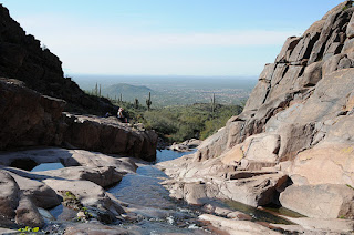
Not too many years ago, getting to Hieroglyphic Canyon in the Superstition Wilderness Area required some effort. A long approach, unclear route and an ever-encroaching quagmire of private property and access restrictions precluded all but the most robust and determined hikers from visiting the canyon and its treasure trove of ancient Hohokam rock art. Recently, the Superstition Area Land Trust (S.A.L.T.) and Pinal County worked together to make Hieroglyhic Canyon more accessible. Through their efforts, a developed trailhead and parking area sprung up where once only limited roadside pullouts served as parking spots. There’s even a porta potty now. At first blush, this was a wonderful accomplishment. These improvements opened up the area to thousands who would otherwise miss the opportunity to learn from and enjoy this national treasure. However, among the trail’s smartly designed informational signage, there’s not a word about the irreplaceable historical significance of the rock art. Archeologists believe the petroglyphs range in age from 2,000 to 200 years old. Images of animals, plants, humans and mysterious geometric designs pecked into the rock veneer give a rare and precious glimpse into the life and culture of Arizona’s native inhabitants. The glyphs are scattered across a segment of the canyon where water runs over stone terraces nearly year-round. It’s a beautiful sight to behold—natural, open and entirely exposed to vandalism and damage from careless visitors. We visited this area early in the morning of February 21, 2009 and arrived at the petroglyph site around 8:30 a.m. By 9:30, the canyon had become overrun with visitors, many of whom proceeded to demonstrate an absolute disregard for historic preservation by climbing on (ON, not around) the artifacts. Young children were allowed to ply the ancient etchings with peanut butter encrusted fingers while cell phone wielding teens teetered atop an elegant set of animal drawings, chattering like baboons as the soles of their shoes chafed the delicate art. Granted, much of this behavior may be happening because people simply do not understand the rock art’s significance and fragility. In fact, while we were there, we conducted an informal query of the perpetrators and found that some of them had no idea the petroglyphs were “real”. Because of all the interspersed modern graffiti, one man assumed that all of the markings were the work of latter-day hoodlums. As the canyon swelled with droves of careless explorers, I struggled with a churning mix of anger, sadness and an urge to scream “get off the friggin petroglyphs!” Instead of making an ass out of myself, I wrote this diatribe—which makes me feel better, but does little to solve problem. You can help by educating your friends, families and co-workers about historical site preservation. Send them the link to this blog posting and the link to the Archeological Site Etiquette Guide shown below. Also, feel free to pester the following agencies at will.
LENGTH: 3 miles round trip
RATING: easy
ELEVATION: 2,050-' 2,620'
GETTING THERE:
From Phoenix, take US 60 east to Apache Junction. Between milesposts 202 and 203, turn left onto Kings Ranch Road and go 2.8 miles to Baseline Road. Turn right and follow Baseline 0.3 mile to Mohican, turn left, go 0.3 miles to Valley View. Turn left and follow Valley View (turns into Whitetail Road) to Cloudview Ave, turn right and continue 0.5 mile to the trailhead.
INFO: Tonto National Forest
http://www.fs.usda.gov/recarea/tonto/recreation/hiking/recarea/?recid=35483&actid=50
Archeological Site Etiquette Guide: http://azstateparks.com/SHPO/etiquette.html Superstition Area Land Trust (S.A.L.T.) http://www.azsalt.org/ Arizona Archeological Society http://www.azarchsoc.org/phoenixchapter.html
Superstition Wilderness
Not too many years ago, getting to Hieroglyphic Canyon in the Superstition Wilderness Area required some effort. A long approach, unclear route and an ever-encroaching quagmire of private property and access restrictions precluded all but the most robust and determined hikers from visiting the canyon and its treasure trove of ancient Hohokam rock art. Recently, the Superstition Area Land Trust (S.A.L.T.) and Pinal County worked together to make Hieroglyhic Canyon more accessible. Through their efforts, a developed trailhead and parking area sprung up where once only limited roadside pullouts served as parking spots. There’s even a porta potty now. At first blush, this was a wonderful accomplishment. These improvements opened up the area to thousands who would otherwise miss the opportunity to learn from and enjoy this national treasure. However, among the trail’s smartly designed informational signage, there’s not a word about the irreplaceable historical significance of the rock art. Archeologists believe the petroglyphs range in age from 2,000 to 200 years old. Images of animals, plants, humans and mysterious geometric designs pecked into the rock veneer give a rare and precious glimpse into the life and culture of Arizona’s native inhabitants. The glyphs are scattered across a segment of the canyon where water runs over stone terraces nearly year-round. It’s a beautiful sight to behold—natural, open and entirely exposed to vandalism and damage from careless visitors. We visited this area early in the morning of February 21, 2009 and arrived at the petroglyph site around 8:30 a.m. By 9:30, the canyon had become overrun with visitors, many of whom proceeded to demonstrate an absolute disregard for historic preservation by climbing on (ON, not around) the artifacts. Young children were allowed to ply the ancient etchings with peanut butter encrusted fingers while cell phone wielding teens teetered atop an elegant set of animal drawings, chattering like baboons as the soles of their shoes chafed the delicate art. Granted, much of this behavior may be happening because people simply do not understand the rock art’s significance and fragility. In fact, while we were there, we conducted an informal query of the perpetrators and found that some of them had no idea the petroglyphs were “real”. Because of all the interspersed modern graffiti, one man assumed that all of the markings were the work of latter-day hoodlums. As the canyon swelled with droves of careless explorers, I struggled with a churning mix of anger, sadness and an urge to scream “get off the friggin petroglyphs!” Instead of making an ass out of myself, I wrote this diatribe—which makes me feel better, but does little to solve problem. You can help by educating your friends, families and co-workers about historical site preservation. Send them the link to this blog posting and the link to the Archeological Site Etiquette Guide shown below. Also, feel free to pester the following agencies at will.
LENGTH: 3 miles round trip
RATING: easy
ELEVATION: 2,050-' 2,620'
GETTING THERE:
From Phoenix, take US 60 east to Apache Junction. Between milesposts 202 and 203, turn left onto Kings Ranch Road and go 2.8 miles to Baseline Road. Turn right and follow Baseline 0.3 mile to Mohican, turn left, go 0.3 miles to Valley View. Turn left and follow Valley View (turns into Whitetail Road) to Cloudview Ave, turn right and continue 0.5 mile to the trailhead.
INFO: Tonto National Forest
http://www.fs.usda.gov/recarea/tonto/recreation/hiking/recarea/?recid=35483&actid=50
Archeological Site Etiquette Guide: http://azstateparks.com/SHPO/etiquette.html Superstition Area Land Trust (S.A.L.T.) http://www.azsalt.org/ Arizona Archeological Society http://www.azarchsoc.org/phoenixchapter.html
Friday, February 20, 2009
PICACHO PEAK
HUNTER TRAIL
Picacho Peak State Park
You’ve got to be just a little bit “nuts” to hike to the top of Picacho Peak. Visible for miles along Interstate-10, the imposing heap of lava looks insurmountable. However, the Hunter Trail, with its network of cables bolted into bare rock, guides adventurous hikers to the top. While climbing up along the vertical hardware, you may find yourself questioning your sanity. That’s because most humans have a built-in fear of heights. Squirrels, on the other hand, do not share this trait. The peak’s resident critters seem to enjoy pestering hikers as they toil up the trail. But, don’t be too concerned -- they’re more interested in the snacks in your backpack than testing your mental fortitude. The exhausting climb to the summit rewards with expansive panoramas of the surrounding desert. From the top, Interstate-10 looks like a desolate pale ribbon leading to nowhere. While ogling the views, be sure to keep an eye on your gear or else a nut-loving squirrel might ambush your backpack and run off with your trail mix.
LENGTH: 4 miles round-trip
ELEVATION GAIN: 1,374 feet
RATING: difficult
GETTING THERE:
From Phoenix, drive 75 miles south on I-10 to exit 219, Picacho Road. Once inside the park, follow the main road to the turnoff for Bartlett Loop. The trail starts at the picnic area at the north side of the loop. Wear boots with good traction and bring non-slip gloves to protect your hands on the cables.
Fees: $6 daily fee per vehicle.
Information: pr.state.az.us/Parks/parkhtml/picacho (520) 466-3183
QUARTZ RIDGE
BUTCHER JONES TRAIL
Tuesday, February 10, 2009
LAVA RIVER CAVE
LAVA RIVER CAVE Coconino National Forest As the Valley swelters in a 100-degree inferno, a subterranean cave where temperatures hover around a brisk 40 degrees all year, beckons heat-weary hikers. Located just 2 hours north of Phoenix in a stand of unassuming Ponderosa pines, the dungeon-like entrance to Lava River Cave spews inviting, cool air. Deep, dark and stony, the 700,000-year-old lava tube lacks the musty, clammy ambiance one might expect. A brief scramble down some boulders to get to the cave floor is a bit tricky, but with long pants and sturdy footwear, not too difficult. The 3/4-mile-long natural wonder winds through absolute darkness over fissured, molten “rivers” and the walls bear the marks of escaping volcanic gasses and hellish temperatures. About half way in, the river divides. One route is a tight fit; the other resembles a medieval cathedral. Both paths lead to the end of the cave, where, although warmer than the temperatures at the entrance, a jacket is required. LENGTH: 1.5 miles roundtrip RATING: Easy. You will need to bring two reliable light sources. ELEVATION GAIN: -100 GETTING THERE: Drive 9 miles north of Flagstaff on US 180 and turn west (left) on FR 245. Continue 3 miles to FR 171 and turn (left) south. Go 1 mile to FR 171B and turn left.
MONTEZUMA WELL
HIGHLIGHTS: Easy trail with educational signs, cliff dwelling ruins and lots to explore. LENGTH: third-mile loop
RATING: Easy. The paved rim trail is stroller and wheelchair friendly. ELEVATION: 3,651’ - 3,681’ DOGS: Park rules require that dogs stay on leash you clean up after your pet and keep him/her off the ruins, on trails and out of the water. Driving distance from Phoenix: 106 miles one-way GETTING THERE: From Phoenix, go north on I-17 to the McGuireville exit #293. Follow the signs for roughly 6 miles to the parking area. Admission is free, however, there’s an entrance fee at sister attraction Montezuma Castle located a few mile south off I-17. INFO: (928) 567-4521 or http://nps.gov/moca
USGS ARTICLE about Montezuma Well: http://pubs.usgs.gov/of/2011/1063/
Saturday, February 7, 2009
FOREST ROAD 48
Subscribe to:
Posts (Atom)


