Find A Trail. Start Your Search Here:

Monday, June 2, 2025

Taawa Trail

TAAWA TRAIL

A steep drop-off on the Taawa Trail

One of Flagstaff’s newest hiking routes is destined to become an Arizona high-country classic.  

Completed in the fall 2024, the Taawa Trail is the last trail to be built in Flagstaff’s Mount Elden-Dry Lake Hills (MEDL) area and is one of the few designated for hiker-only use.  The challenging yet approachable path seamlessly melds easy mountain traipses with aggressive climbing. 

A survivor Alligator Juniper on the Taawa Trail

It’s kind of like eating ice cream with habanero sauce.

The close-to-town MEDL trail system has been popular with non-motorized trail users since its debut in 1987. In addition to its recently expanded menu of new stacked loops, the area also shares space with the Arizona National Scenic Trail and the Flagstaff Loop Trail.

Volcanic boulders line the Taawa Trail

View of the San Francisco Peaks from Taawa Trail

Trail planning, design and construction was a hyper-local effort with contributions from the U.S. Forest Service Coconino National Forest Flagstaff Ranger District, American Conservation Experience, and many volunteer hours and fundraising events organized by local bike organizations and local businesses.

The Taawa Trail is for hikers only

The results are breathtaking.  New signage mitigates the formerly confusing and disruptive unauthorized paths.  Beautiful singletracks follow the natural contours of the land as they meander through diverse eco zones that rise from pinion-juniper woodlands where tiny cacti huddle among boulders to aspen glens and high elevation fir-spruce forests.  All in just a few miles of switchback-mitigated climbing.

Claret cup cactus color the trails May -July

The Taawa Trail –which is named for the Hopi word for sun spirit or creator--replaces a maze of social paths including the Lost Burrito Trail on its lower half. 

Access Taawa Trail from the Rocky Ridge Trail

The trail’s upper segment is all new, sustainable construction aligned to protect wildlife, keep hikers safe and deliver an exceptional outdoor experience.  The 2.1-mile trail that ascends more than 1,000 feet can be accessed from the Shultz Creek Trailhead by hiking 0.6-mile on the Rocky Ridge Trail to the Taawa junction. 
A steep, tricky spot on the upper Taawa Trail

It’s easy going for the first mile up to where the trail makes its first crossing of the Big Bang Trail. 
Make a return loop using the Big Bang Trail

That’s where a set of tight, edgy switchbacks take on the foothills.  Steep and exposed, the thin path climbs steadily through stony passages in pine-oak woodlands. 
A shady segment on the Taawa switchbacks

The vertical assault calms down after about a half mile, leveling out in patchy high meadows where trees part just enough to give up fantastic views of the San Francisco Peaks and the town of Flagstaff below.  The trail ends at its high point at the second Big Bang Trail junction.
Summer storms build quickly in mountain climes

From here, hikers can either back track or make a return loop using Big Bang for a slightly longer, more challenging trek.

LENGTH:  5.4 miles out-and-back as described here.  6.4 miles with Big Bang return option.

RATING:  moderate-difficult

ELEVATION: 7,160 – 8,422. feet

GETTING THERE:

Schultz Creek Trailhead: In Flagstaff, go 3 miles north on U.S. 180 (Humphreys Street) and turn right on to Schultz Pass Road (Forest Road 420). Continue 0.5-mile on FR 420 and make a hard left at the Elden Lookout Road (Forest Road 577) "Y" and go another half mile on FR 420 to the parking area on the left.  There are no fees or facilities at the trailhead. 

INFO:

https://www.fs.usda.gov/r03/coconino


Tuesday, April 29, 2025

Piloncillo Ant Hills

PILONCILLO ANT HILLS

Cottonwood Basin Fumaroles

Ever see that movie “Them!”?  The 1954 black-and-white atomic-age chiller tells the story of mutant ants that go about eating humans in the New Mexico desert.  According to archival promotional clips, the monsters, mutated by atomic bomb test radiation, “claw out of the earth from mile-deep catacombs.”  Over the course of the film, it’s revealed that the ants are colonizing through underground tunnels, commandeered storm drains and rogue queen bees who have flown off to establish new nests.

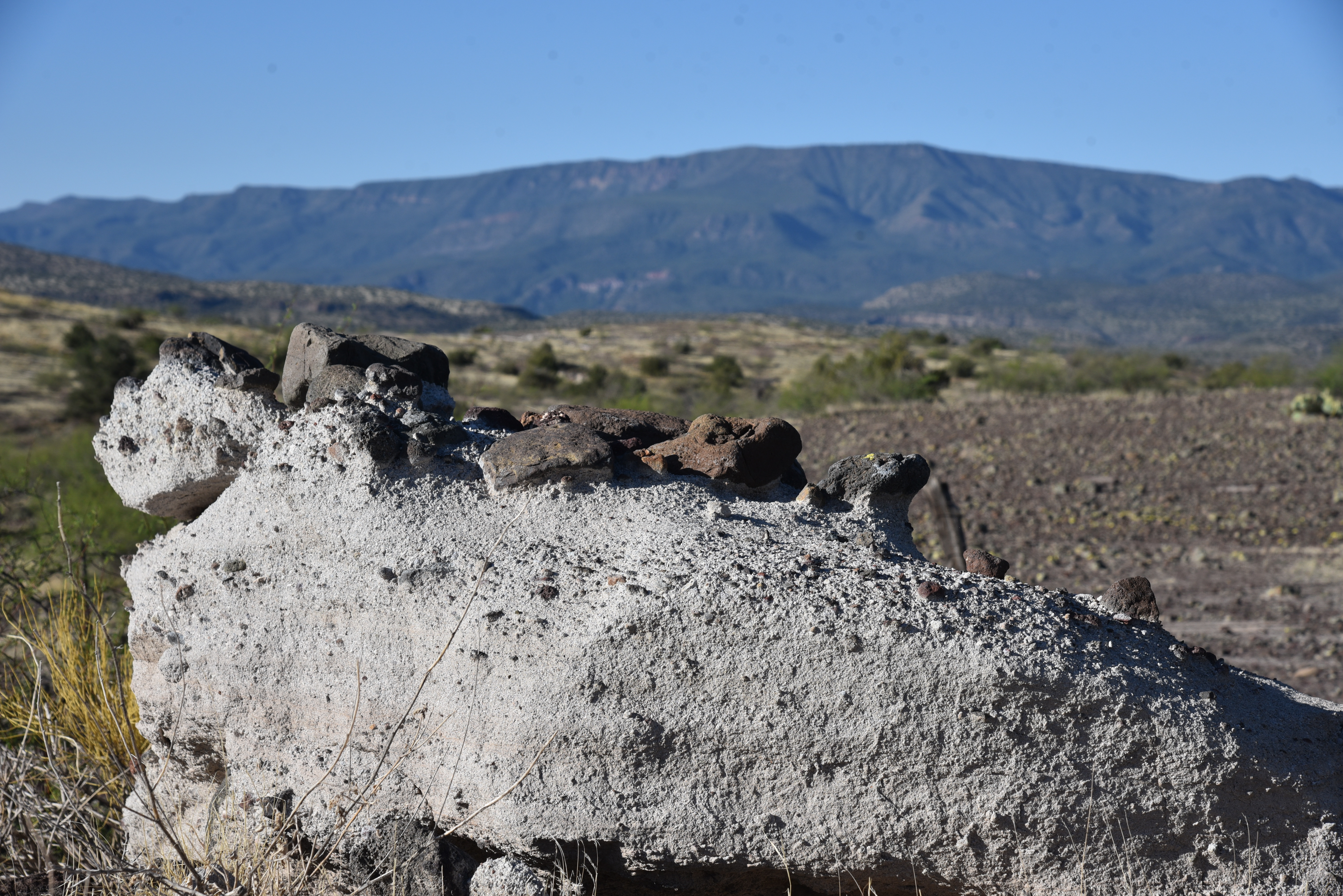
Volcanic ash deposits along Fossil Creek Road

 Throw in some awesome flamethrower action, poison bombs, traumatized kids and vintage military aircraft and you’ve got the makings of a classic. Spoiler alert: in addition to their appetite for human flesh, the ants also like sugar.  
Chunks of basalt spill over volcanic ash on FR500

While the movie was filmed in what looks suspiciously like Joshua Tree National Monument, there’s a place in Arizona that could have provided a deeper sense of foreboding to the movie’s  bleak and tense theme.  Located 10 miles east of Camp Verde, the Cottonwood Basin Fumaroles in Coconino National Forest would make for a believable backdrop for mutant ants. 
Strawberry hedgehog flower among basalt & ash

The USGS defines fumaroles as “vents from which volcanic gas escapes into the atmosphere. Fumaroles may occur along tiny cracks or long fissures, in chaotic clusters or fields, and on surfaces of lava flows and thick deposits of pyroclastic flows. 
FR500 overlooking the fumaroles

They may persist for decades or centuries if they are above a persistent heat source or disappear within weeks to months if they occur atop a fresh volcanic deposit that quickly cools.” Geologists say that the Cottonwood Basin Fumaroles formed from volcanic ash deposited by nearby Hackberry Volcano that fell on an ancient freshwater lake about 7 million years ago.  The ash hit the calcium-rich water forming cement-like layers from which stream vented. 
Mountain vistas on FR 500

Over millions of years, the lake dried up and softer ash eroded away, leaving conical, honey-combed formations of petrified ash behind.  Locally known as the Tee Pee Rocks, the strange-looking array is tucked away in a shallow canyon just a few steps off Fossil Creek Road.  Visitors travelling on FR708 heading toward Fossil Creek Wild and Scenic River Sites usually fly right by this curious side attraction.  But a short hike leads to a couple of overlooks for views of the odd geological features.
Overlook on FR 500A

To visit the site, hike one mile downhill from the parking area off SR260 at Fossil Creek Road to FR 500 on the right where there’s a large primitive camping area. Then, hike 0.3-mile on FR 500 to an overlook.  Below, the chain of fumaroles appear as a sort of Pompeii-meets-Wat-Arun or Namibian termite hills gone wild.  With a nod to sugar-loving atom ants, “piloncillo ant hills” would be an apt description as well.

Scrambling down into the basin is not for amateurs. The area is rife with loose rocks, slippery inclines and hidden cracks poised to twist ankles. This is also prime rattlesnake habitat.  The fragile formations may have survived 7 million years of exposure, but it wouldn’t take much abuse from humans to destroy what’s left. So, it’s best to leave them alone and take in the sights from the overlooks. A second overlook is at the end of super-short FR500A, which starts at the camping area.  

Ash and xenoliths along Fossil Creek Road

Although the Tee Pee Rocks are the main attraction of this hike, that’s not all there is to see.  Geology nerds are treated to all manner of volcanic debris along the way.  Road cuts expose layers of volcanic rock, odd outcroppings stuffed with xenoliths and fields of colorful basalt blobs atop chalky slabs of hardened ash—all backed by cinematic mountain views.  Whether hiked alone or as a detour on the way to Fossil Springs, viewing the Tee Pee Rocks is a must-do for fans of Arizona weirdness.

Back home, re-imagine the hike by watching “Them!” with a sugary treat.  It’s probably streaming somewhere.

LENGTH: 3.7 miles round trip

RATING: moderate

ELEVATION:  3,429 – 3,315 feet

GETTING THERE:

From Interstate 17 in Camp Verde, go 10 miles east (toward Payson) on State Route 260 to Fossil Creek Road (Forest Road 708) on the right.  Park in the designated spaces. 

LEARN MORE ABOUT FURMAROLES:

https://www.usgs.gov/news/earthword-fumarole


Monday, April 7, 2025

Jawbone Windmill

JAWBONE WINDMILL

Corral at the Jawbone Windmill site

Words on maps can be both enticing and deceiving.  While indispensable for navigation, the two-dimensional limitations of maps can’t touch the experience of walking in the spaces they represent.

Bill Williams Mountain on the center horizon

Take for instance Jawbone Windmill, a nondescript line item that appears on the Coconino National Forest map.  A dot in the landscape 15 miles east of Camp Verde, the name stokes curiosity. 

Water tank at the Jawbone Windmill site

The moniker oozes a vaguely carnivorous mood rife with scattered bones, roaming livestock and skulking wildlife, all sustained by a wind turbine pumping life-sustaining water.  How can this enticing destination not be explored?  The go-see trek uses Forest Road 9243C, a rough two-track, that starts at a dirt parking apron on State Route 260. 
A mesquite tree on the high meadow

While the hike to the site is just under 4 miles round trip, the undulating road’s dips and climbs add up to over 1,100 feet of accumulated elevation change--another fact not easily apparent on maps.
Thirteenmile Rock Butte on right

 
Immediately past the roadside gate, FR9243C crosses paths with the General George Crook Trail #130.
A steep incline in FR9243C

The unsigned crossroad parallels the highway and is part of the historic military supply route that runs for miles across Central Arizona. But that’s a trip for another day. For this hike, continue straight ahead as the road bends east and then north on its way into the hilly landscape. 
Yucca frame views on the high meadow

The prominent 5,515-foot flat-topped profile of Thirteenmile Rock Butte and its companion 5,283-foot unnamed pointy peak stand out to the east over the first quarter mile.  The easy start, which also passes by a rustic metal water tank, is soon disrupted with the first of several steep descents along the jumbled, juniper-lined road.  But not before giving up sweeping vistas of the Verde Valley, Bradshaw Mountains and the stony gorge of West Clear Creek.  On clear days, Bill Williams Mountain in Kaibab National Forest can be sighted on the far northwest horizon.  
The dry basin of Wire Corral water hole

At the 0.4-mile point at the bottom of a ravine, a faint dirt spur road heads off to the left.  This leads to the Wire Corral water hole.  Dry as a bone—and littered with actual bones—the tiny earthen-dam-backed reservoir is a reminder that Arizona is in long-term drought cycle.  Domestic livestock and native wildlife depend on these created catchments for survival. 
View of the winding road from near the trailhead

Although we cannot control the precipitation needed to replenish them, we can make a difference by donating to the Arizona Game & Fish Department’s Send Water program (link below) to help fill and maintain 3,000 water holes across the state.  It’s an easy way to help ensure wildlife survival.

Beyond the of basin of bones, the road makes another vertical assault, this time on the edge of a gorge overlooking the community of Clear Creek. The ankle-twisting haul tops out on a large high-desert meadow where mesquite, yuccas, agave and cacti frame some of the widest panoramas of the hike.  After a few hundred yards of painless walking, the road plunges again to where a major drainage bisects it at the 1.6-mile point. 

Mingus Mountain viewed fro FR9243C

Here, a side road veers off to the left.  The unsigned route leads to the mystery on the map—Jawbone Windmill.  At just over 0.2-mile in length, the road makes a mild descent to the weedy local. In the middle of shadeless folds of hills, a rusty water tank stands among encroaching catclaw. 
Bolts on the Jawbone water tank

There’s no windmill.  A concrete trough, foundations, decaying corrals and piles of pipes, sheet metal and random parts contribute to a curious array of detritus.  An adjacent water hole is dry.
Faint road on left leads to the windmill site

 
Cracked mud enshrines the footprints of deer, bobcats, skunk and cattle that came to drink from residual pools left from sporadic rains.  
Gate at the trailhead on State Route 260

Despite the dismal water situation, this is beautiful country.  Mountain peaks soar over the weather-raved remains, scrub jays screech from pinon pines and in the gulch that empties into the water hole, a family of deer graze before disappearing quietly into the scrub.

LENGTH: 3.8 miles round trip

RATING: moderate

ELEVATION: 4,367 – 4,698 feet (1,128 feet of elevation change)

GETTING THERE:

From Interstate 17 in Camp Verde, travel 15 miles east (toward Payson) on State Route 260 to the parking turnouts at milepost 233. Hike begins at the FR9243C gate.

Arizona Game & Fish Send Water Program:

https://www.azwildlifehero.com/programs/lifesaving-water

Monday, March 24, 2025

Hot Loop Trail

HOT LOOP TRAIL

Woods Canyon viewed from Hot Loop Trail

In the wrong hands, a hike like the Hot Loop could go bad.  Forest Service signs on the trail warn of extreme conditions, sketchy sections and the fact that the “loop” involves connecting with Jack's Canyon Trail for a rugged 22-mile trek. 

Bell Rock, Bear Mtn and Courthouse Butte

While the full trip is clearly not for everybody, there are less treacherous yet still challenging options to sample some of the best parts of the trail.
Cypress woodlands on Hot Loop Trail

The 12.6-mile Hot Loop trail in Coconino National Forest near the Village of Oak Creek, has two main access points, the Jack's Canyon trailhead—as described here, and the Woods Canyon Trailhead near the Coconino National Forest visitor center along State Route 179.
Horse Mesa seen from Hot Loop Trail

Neither trailhead hints at the precarious nature of what lies ahead. Rough terrain, little shade, steep drop-offs and the potential for springtime floods could put a fatal kink in trail user plans.

The less-crowded Jack's Canyon trailhead is the preferred launch site for day hikers. The trail starts at the west end of the parking area near a corral.  The first half mile is an easy stroll among mesquite and cactus skimming bucolic ranch properties that bump up against the forest boundary.

Scrubby landscape above Woods Canyon

The hike’s transportive quality soon kicks in as the terrain moves from flat fields to hilly cypress-and-yucca foothills giving up good views of iconic rock formations Courthouse Butte and Bell Rock.
Overlooking Village of Oak Creek

 Narrow and rocky, the singletrack path initially takes it time moving up the lower slopes of Horse Mesa.  Pinon pines and shaggy-bark cypress trees throw bits of shade on the track as it reveals bigger and better vistas around every turn.  At around the 1-mile point, the trail makes a pronounced northeast bend, passes a gate (close it behind you) and then descends slightly onto slick rock ledges above the chasm of Woods Canyon.  Cupped in the folds of the mesa the trail dip is a short-lived respite before the trail takes on a ferocious mile-long climb.  Some loose rock and edgy traverses can be unnerving, but well-equipped hikers should have little trouble picking their way up the 1000+-foot ascent. 
Edgy ascent of Horse Mesa

Trail users should be prepared.

The huffing and puffing ends at the lip of the scrubby mesa and enters the Munds Mountain Wilderness area.  A short walk reveals panoramic views of the Pine Valley community, Sedona’s red rock formations, the deep cut of Woods Canyon and Dry Beaver Creek and the distant silhouettes of Capitol Butte and Bear Mountain. 
Jack's Canyon trailhead


For the casual day hiker, the rim makes for a good turnaround point for a satisfying 3-miler.

LENGTH: 6 miles round trip to top of the mesa as described here.

RATING: difficult

ELEVATION: 4,234 – 5,200 feet

GETTING THERE:

Jack's Canyon Trailhead:

From Interstate 17 north of Camp Verde, take the Sedona/Oak Creek exit 298 and continue 6.5 miles on State Route 179 to the Jack’s Canyon Road/Verde Valley School Road traffic circle. Veer right and continue 2 miles on Jack’s Canyon Road to the trailhead on the right. Roads are paved up to the trailhead. There are no fees or facilities at this trailhead.

Woods Canyon Trailhead (alternate access):

From Phoenix, travel north on I17 to exit 298 for SR179, Sedona-Oak Creek, go left (west) and continue 8.5 miles to the turn off for the Red Rock Ranger District Station on the right.  Trailhead is located within the ranger station complex in the south (lower) lot where a small metal sign indicates the start point.

INFO:

https://www.fs.usda.gov/recarea/coconino/recreation/recarea/?recid=54992&actid=50

Tuesday, March 18, 2025

Buckskin Hills

BUCKSKIN HILLS

Mountain vistas from FR 9C

What’s most remarkable about Arizona’s vast in-between spaces is their sneaky way of delighting.  Take for example, the windy rangeland that lies between the Fossil Springs and West Clear Creek Wilderness Areas in Yavapai County. 

A water hole in the Buckskin Hills

From State Route 260, the scenic byway that runs between the two magnetic recreational destinations, the shrubby hills belie pockets of beauty seen only by those willing to take a chance on one of the dozens of nondescript dirt roads that meander through them.
Snow coats FR9C on March 16, 2025


Located 20 miles east of Camp Verde on the Coconino National Forest, the Buckskin Hills usually don’t make the bucket lists of outdoor enthusiasts. 

The view from above Fossil Springs Wilderness

The low-slung ridges that just barely scrape 6,000 feet at their highest point are cluttered with junipers, cactuses and dozens of wildlife water holes.  Forest Road 9C, which swerves off SR 260, serves as an introductory path for exploring the area that hikers may approach with low expectations.
 Water hole below the Buckskin Hills

Brilliant in its ordinariness, the simple road hike has a simmering energy that builds in a slow, steady cadence.

From the dirt turnouts that serve as a trailhead, the waters of Divide Tank reflect mountain peaks, teasing at what lies ahead. 

Divide Tank at the start of the hike

Forest Road 9C is unsigned for most of its length, tucking into a visually underwhelming swath of rangeland.  But only for  a while.  Soon, the mangled, boulder-lined route encounters rustic tangles of corrals and stock tanks tethered by a web of primitive dirt roads.  Jackrabbit jump scares and ravens casting shadows on the tire-torn red-earth roads are the untamed supporting characters that break the dead silence.

Junipers are the dominant trees in the area

Within a half mile of easy walking, the rounded ridges of the Buckskin Hills appear, closing in in the road.  

Glimpses of distant mountains abound

Here, the landscape rises above its ordinariness with first glimpses of breathtaking mountain vistas.  Getting to the big vistas feels like a cheat.  
Ranch relics dot the landscape

There’s no grueling climb, no long-distance haul; they just creep up and spill the goods.  From this perch above the chasm of Fossil Springs, panoramic views include looks at the mountains and mesas of three National Forests: Coconino, Tonto and Prescott.  At the 1.5-mile point, the road meets and unnamed water hole.  Wrapped in metal gates and wire, the water containment serves wildlife and domestic cattle, especially during summer heat and prolonged droughts.  Oaks, junipers and ash trees huddle in the dammed drainage nearby providing shade, cover and nesting environments adjacent to the life-giving oasis.  More surprises and quiet beauty lie ahead on Forest Road 9C and its tangents for hikers willing to bet on the outwardly ordinary.

LENGTH:  3 miles to the water hole and back

RATING: moderate

ELEVATION:  6,042 – 5,707 feet

GETTING THERE:

From Interstate 17 in Camp Verde, go 21 miles east (toward Payson) on State Route 260 to Forest Road 9C on the right between mileposts 238 and 239.  Park in the turnouts. Be sure to close the access gate behind you.