Find A Trail. Start Your Search Here:

Wednesday, August 28, 2024

Tonteel Trail

TONTEEL TRAIL

Schultz Tank views from Tonteel Trail

Schultz Tank has long been a popular stopping off point for trail users in Flagstaff’s Mount Elden Dry Lake Hills (MEDL) area.  The created water hole is located between the low-slung volcanic mounds collectively known as the Dry Lake Hills and San Francisco Mountain, the dormant stratovolcano that hosts Arizona’s highest hiking destination: Humphreys Peak trail.

Tonteel Trail cross a dam at Schultz Tank

Schultz Tank is contained by two constructed earthen dams, and while it’s a year-round reliable water source, its size vacillates according to season and precipitation. Tonteel is a Dine (Navajo) word for “ocean” or ”water that is wide”.

Pines shade parts of the Tonteel Trail

Whether overflowing as it’s known to do in spring, or wanning as autumn approaches, there’s always enough water to attract wildlife and support a burgeoning fringe of vegetation. 

A flotilla of ducks on Schultz Tank

Ducks are ubiquitous and large game like elk and deer appear mostly around dawn and dusk.

Situated at 8,000 feet, the glassy pool is also a hub for hikers, equestrians and mountain bikers. Recent trail development in the area has extended hike options far beyond the old standard routes like Sunset, Brookbank and the Arizona National Scenic Trail. 

The short, scenic loop is family-friendly

The new Tonteel Trail anchors the hub both literally and figuratively.  The half-mile, family-friendly path circles the tank forming a sort of wagon wheel loop from which other forest trails spin off like spokes.
Schultz Tank serves as a trail hub

Mountain breezes ruffle Schultz Tank waters


The trail is a simple, easy trip around the water ducking in and out of pines and over the dams where blooming shrubs attract swarms of butterflies, bees and dragonflies.  Mountain vistas reflect into the often wind-ruffled pool beloved as a grounding point for day hikes, picnics, wildlife watching or filtering water before backpacking into the surrounding mountain wilderness.

New Mexican vervain blooms June - September


LENGTH: 0.5-mile loop

RATING: easy

ELEVATION: 7,961 – 8,029 feet

GETTING THERE:

Schultz Tank Trailhead:

From Flagstaff, travel north on U.S. 180 (Fort Valley Road) to milepost 218.6 and turn right on Schultz Pass Road (FR420).  Continue 0.5-mile on FR420 to a fork, veer left to stay on FR420 and continue 4.8 miles to the Schultz Tank trailhead on the right. Schultz Pass Rd is maintained dirt suitable for all vehicles.

Day use only. No camping.

FACILITIES: restroom

INFO & MAPS:

Coconino National Forest

https://www.fs.usda.gov/detail/coconino/recreation/?cid=FSEPRD1169467#schultztank


Tuesday, August 27, 2024

Broadside Trail

BROADSIDE TRAIL

Mixed conifer forest on Broadside Trail

Moody Blue.  Don’t look for it on the color wheel, fashion catwalks or in the prog rock song book.  It’s a color buried so deep in the visible light spectrum it defies description.

A tree shaded meadow on the Broadside Trail

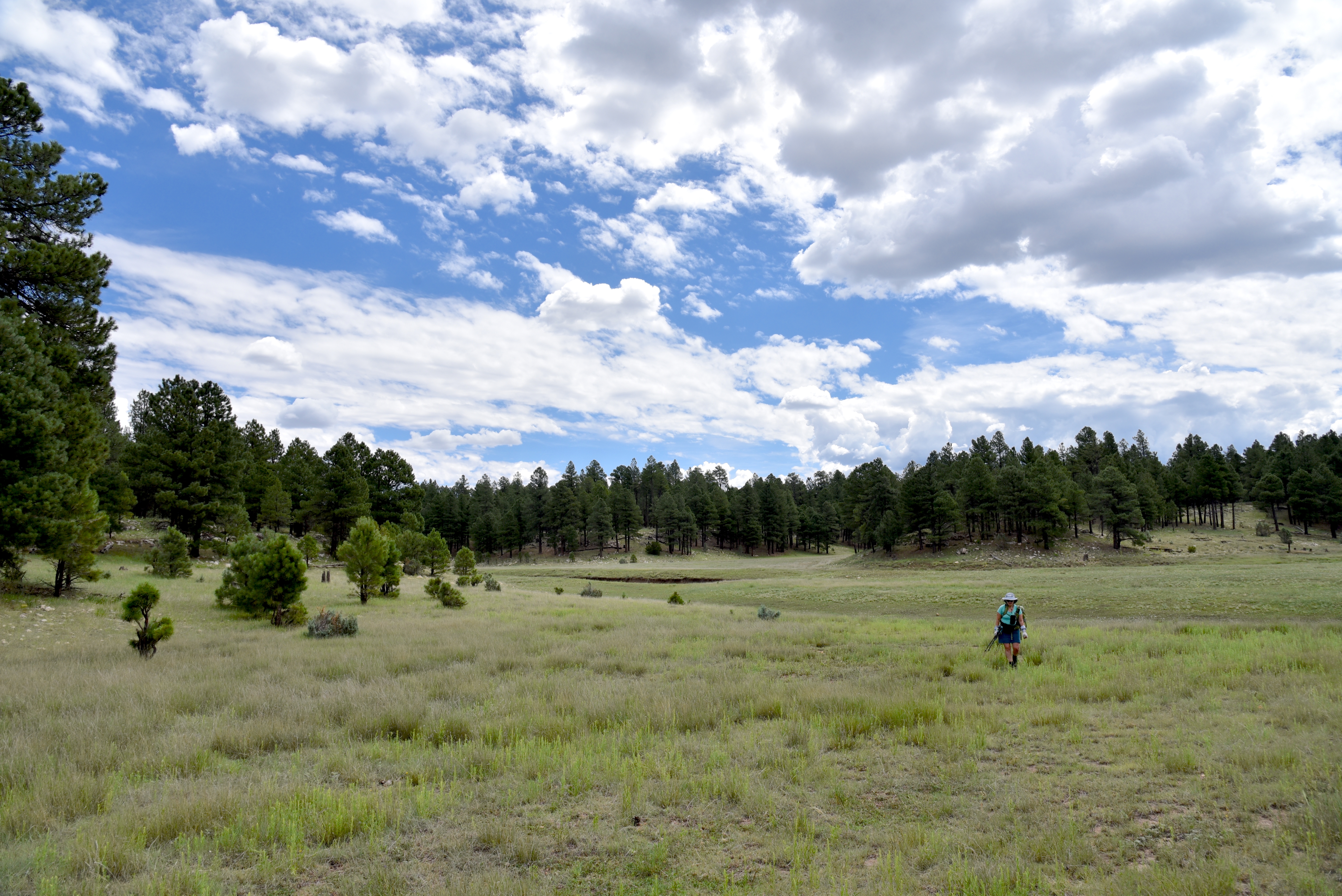
It shows up in nature in the underside of storm clouds, inside a faded lupine bloom, imbedded in fir needles and within the fine grains of volcanic rock.
It’s an icy color with a bitter sting.  It smells of pine sap and mint---not the sweet culinary kind---but the rude, wild stuff that grows around forest water holes. Rather than a one-note visual, Moody Blue is a whole-body experience.  On cloudy summer days, it’s abundant on the Broadside Trail. One of the newer additions to Flagstaff’s Mount Elden-Dry Lake Hills (MEDL) Trail System, the Broadside Trail flows through cool woodlands in a pocket of foothills between the San Francisco Peaks and Mount Elden.  The 3.4-mile fresh cut route joins old standards Sunset and Brookbank trails for a shady trek in Coconino National Forest.
Moody blue in the clouds

The close-to-town MEDL system has been popular with non-motorized trail users since its debut in 1987. In addition to its ever-expanding menu of new stacked loop trails, the area also shares space with the Arizona National Scenic Trail and the Flagstaff Loop Trail.

The Broadside Trail opened in 2023, but until August 16, 2024, when Schultz Pass Road and Elden Springs Road were reopened following post-fire restorations, getting to it required hiking on long connecting trails.  With drive up options to the Sunset and Schultz Tank trailheads restored, hikers now have direct access. 

New MEDL trails are well signed

The MEDL area has survived numerous disasters.  Scorched by the 1977 Radio Fire, 2010 Schultz Fire, 2019 Museum Fire and most recently by the 2022 Pipeline Fire, the corrugated landscape is being rehabilitated with forest clearings, flood control projects, new sustainable trail alignments and the elimination and/or adoption of social trails for better overall environmental health and public safety.  

Contributors to the trail planning, design and constructions are U.S. Forest Service Flagstaff Ranger District, American Conservation Experience, Arizona Conservation Corps, Flagline Trails, and many volunteer hours and funding efforts from Flagstaff Biking Organization.

Slash piles from forest restoration work

 
Richardson's geranium blooms April - October

The results are breathtaking.  New signage mitigates the formerly confusing and disruptive maze of unauthorized paths.  Beautiful singletracks follow the natural contours of the land as they meander through diverse eco zones that rise from pinion-juniper woodlands where tiny cacti huddle among boulders to aspen glens and high elevation fir-spruce forests. 

Sunny meadow on the Broadside Trail

All in just a few miles of switchback-mitigated climbing.

The Broadside Trail starts high in the hills around Schultz Tank. 

Clouds build over the San Francisco Peaks

At the Sunset Trailhead, snap a photo of the trail map to use for your return route options. Broadside immediately enters fragrant pine-shaded foothills, staying flat and easy for its first mile.  
Broadside begins at the Sunset trailhead

The trail ascends to its high point on long switchbacks that ease the climb and maximize scenic views.  Glimpses of fire-singed foothills and the San Francisco Peaks are visible where thick tree cover is disrupted by alpine meadows rife with colorful lupine, wild geranium and thistles.  
Purple locoweed blooms June - September

During summer monsoon season, clouds gathering over the peaks is a near daily occurrence. Near the top of Broadside Trail, where it meets connecting routes Full Sail and Sunset, look for Moody Blue in the sky and underfoot. 
Trailhead map kiosk shows loop options

How will you know when you’ve spotted it? Well, when attempting to describe color in the natural world, words are often inadequate. Ridiculous, really. 
Words do not suffice...

Paint might do better. Moody Blue is a made-up name for the mutable shade that might include a mix of ultramarine, cobalt, burnt umber, vermillion and gold all grayed down with a dab of titanium white.  Who knows?  Writing dances around the visible outer crust. Painting exposes the soul.  This trail and its signature blue needs some paint.
Lupine bloom June - October

LENGTH: 3.24 miles one way or 5.1-mile loop using Sunset Trail or 6.6-mile loop using Full Sail.

RATING:  moderate

ELEVATION: 8,108 – 8,800 feet

GETTING THERE:

Sunset Trailhead

In Flagstaff, go north on U.S. 180 to Schultz Pass Road, turn right and continue 5.4 miles to the Sunset trailhead on the right.  Schultz Pass Road is maintained gravel/dirt suitable for most vehicles. Schultz Pass Road reopened August 16, 2024, following repair work needed after  the 2022 Pipeline Fire.  No facilities.

INFO:

Coconino National Forest

https://www.fs.usda.gov/recarea/coconino/recreation/recarea/?recid=84557&actid=50


Monday, August 26, 2024

Quaky Trail No. 741

QUAKY TRAIL No. 741

Quaking aspens on the new Quaky Trail No. 741

It’s only a mile long, but the new Quaky Trail No. 741 in Prescott National Forest is a handy addition to the Bradshaw Ranger District routes in the Copper Basin Area. 

Quaky Trail traces Aspen Creek

Opened this summer, the new single-track path is located just a few miles from Downtown Prescott and provides connectivity with several popular forest trails like Wolverton Mountain as well as the 51-mile Prescott Circle Trail. 
Quaky Trail connects with popular routes

The fresh-cut Quaky Trail may be accessed from either the Aspen Creek Trailhead or the nearby new Copper Basin Trailhead which will have room for equestrian trailers when completed in late August.
New Copper Basin trailhead offers trailer parking

 Either way, the trail is a beautiful work of construction.  From the Aspen Creek Trailhead, the hike begins with a 0.2-mile walk on Aspen Creek Trail No. 48. 
Butterfly weed blooms May - September

Trail no. 741 heads right following the course of the creek. 
The aspen passage on Quaky Trail

The entire route is shaded by Ponderosa pines and creekside stands of boxelders, locust and oaks with an understory of brambles and wildflowers. 
Ponderosa pines on Quaky Trail

The edgy route twists through the forest dodging boulders and skimming ravines before encountering a gorgeous passage lined with aspen trees.  
Quaky Trail spins off Aspen Creek Trail No. 48

The white-trunked quaking aspens (presumably the “quakies” of the Quaky Trail) huddle in tight formation, their canopies rustling in the mountain breezes. 
Quaky Trail is richly shaded

This is a good trail to keep in mind for October autumn foliage hikes.  The trail ends at the Copper Basin Trailhead where hikers may double back or consult forest maps to extend the trek.
Fleabane grows along Aspen Creek May-October

LENGTH:  2.4 miles out-and-back

RATING: moderate

ELEVATION:  6,341 – 6,614 feet

GETTING THERE:

ASPEN CREEK TRAILHEAD:

From Courthouse Square in Prescott, go 1 mile south on Montezuma Street (turns into State Route 89/White Spar Road) to the traffic light at Copper Basin Road.  Turn right and continue 4.6 miles on Copper Basin Road (turns to good dirt after 1.6 miles) to the Aspen Creek trailhead on the right. The hike begins across the road on Trail 48. No facilities.

COPPER BASIN TRAILHEAD:

Located 0.2-mile past the Aspen Creek Trailhead on Copper Basin Road. No facilities.

Copper Basin Road is maintained dirt suitable for all vehicles up to the trailheads. 


Wednesday, August 21, 2024

The Hike Book Vol. 4

PHOENIX Magazine The Hike Book Vol. 4 is here!


My latest collection of Arizona hikes.
AVAILABLE ONLINE NOW.
In stores in the coming weeks at:
Sprouts
Whole Foods
Wide World of Maps
Just Roughin It
AZ Hiking Shack
REI
Changing Hands Bookstore
Barnes and Noble

Monday, August 5, 2024

Willow Valley Dam

WILLOW VALLEY DAM

Sign on FR9352Q

Willow Valley on the Mogollon Rim is best known for its narrow, cliff-bound course. Rugged back country trails including Maxwell, Tramway, Calloway and the milder Willow Crossing lead into its chiseled sandstone depths in West Clear Creek Wilderness. At its lower reaches, Willow Valley merges with Clover Creek where both empty into West Clear Creek.

Bar D Corral on FR 93

Experienced, well-equipped hikers must brave rough roads, sketchy vertical descents, wading and scrambling to explore the wilderness end of the Coconino National Forest valley located roughly 40 miles south of Flagstaff.
Flat Draw Tank near Bar D Corral


But the valley’s upper reaches in the Plateau Lakes region southeast of Mormon Lake are a whole other story.  On the windy expanse, the valley is a shallow, yawning break in the landscape, hemmed in by fringes of Ponderosa pines. 

Calliopsis bloom June - September

It’s a beautiful, more accessible side of the valley. Replete with water holes, corrals and a maze of dirt roads, the bucolic slice of forest stands in stark contrast to its deeper, wilder end.
Scene along FR 93

A few miles south of the community of Happy Jack, off Lake Mary Road, Forest Road 93 serves as a route to Willow Valley Dam and a quiet pocket of forest that’s easy for just about anybody to explore on foot.

The hike follows Forest Road 93, a level dirt track with lots to see along the way. 

Wild geranium bloom May - September

At the 0.75-mile point, the road meets Bar D Corral, a collection of barbed wire, fencing and other cattle roundup structures.  Nearby, the glassy pools of Flat Draw Tank reflect trees and sky while providing water for wildlife and domestic cattle. 
Willow Valley scene on FR234C

Another mile, and the road comes to Wingfield Corral with its tangle of fencing and complex construct of metal and wood.  At the  north end of the corral, a secondary dirt road heads east. 
The breached Willow Valley Dam

It’s not signed, but this is Forest Road 234C, a 0.2-mile route that crosses over Willow Valley south of the dam. It’s a fun detour, but to get to the dam, skip FR234C and continue 0.2-mile past the corral and head right on Forest Road 9352Q which is open only to foot travel. 
Puddle in the break of Willow Valley Dam

The 0.3-mile dirt road ends at a grassy swale.  Open to the sky, the wide depression is also known as Willow Valley Lake. 
While rain-scoured channels and ample greenery hint that water occasionally runs through, the Willow Valley Dam that had contained the “lake” has partially collapsed. 
Willow Valley Dam seen from FR 9352Q

The earthen embankment is still impressive, though. Its shrub-encrusted walls stand high above the valley with ephemeral puddles at its base. 
Willow Valley "Lake" is a moist swale

Wildflowers thrive in the moist soil and robust elk tracks suggest that the site is still an important wildlife resource.  
Wingfield Corral on FR 93

Forest Road 9352Q continues up a knoll to a shady overlook above the dam that frames picture perfect views of a snippet of Willow Valley’s origin story.

LENGTH:  6 miles roundtrip (out-and-back to the dam beginning near Lake Mary Road)

RATING: easy

ELEVATION:  6,924 – 6,745 feet

GETTING THERE:

From Flagstaff, go 42 miles south on Lake Mary Road (County Road 3) to Forest Road 93 on the left past milepost 302 signed for Willow Valley Dam.  Park along any of the dirt turnouts or dispersed camping sites along the road.  FR93 is maintained dirt suitable for all vehicles for about a mile. After that, high clearance is recommended.

Monday, July 15, 2024

Iron Spring Connector-Leap Frog Trail

IRON SPRINGS CONNECTOR-LEAP FROG TRAIL

Hikers on the Iron Springs Connector Trail

Trails in the forests around Munds Park cater to visitors of many ilks. 

Frog Tank in the Munds Park Trail System

The slice of Coconino National Forest 20 miles south of Flagstaff is home to the Munds Park Trail System and the Kelly Motorized Trail System.  Both systems of looped trails fill the space between Interstate 17 and the Sandy’s Canyon area on Lake Mary Road with over 100 miles of recreational routes.  
Horse Park thinning project on Leap Frog Trail

Whether used for hiking, mountain biking or off-road motorized travel, the system’s menu of short and long loops makes for an ideal outdoor fun destination.  The Munds Park Trail System has several convenient trailheads located just a few miles east of Interstate 17. 
Lizard strikes a pose on Iron Springs Connector

The Iron Springs Trailhead offers quick access to the area’s most popular trails, the Mud Tank Trail and the Frog Tank Loop.  Also departing from the same trailhead, the Iron Springs Connector is a rocky two track that’s open to hikers, bikers and smaller OHVs. 
Ponderosa pines shade Frog Tank Loop

The mile-long route may be used as the first leg in any number of out-and-back or loop hikes.  The trailhead kiosk has maps showing the layout of both systems. 
Oaks and pines on Iron Springs Connector

The Munds Park trails are mostly rated as easy-moderate and are short in length while the Kelly trails are designed for OHV use and are longer and more difficult.  All the trails wander through Ponderosa pine forests with patches of sunny meadows and lots to see.
Wild bergamot blooms in moist areas

For a moderate out-and-back day hike, follow the Iron Springs Connector to the Frog Tank Loop junction.  Go right at the junction and follow the trail that’s also open to motorized use, downhill to where it crosses a drainage replete with summer wildflowers and tiny pools. 
Domestic cattle share the trails

At 0.2 mile from the Frog Tank Junction, the trail meets a 3-way intersection.  Continue straight onto the Leap Frog Trail #246 which is also known as the Buried Cable Trail.  The trail is not signed here, but utility posts along this 0.3-mile segment serve as identifiers.  At the 1.5-mile point, the trail reconnects with the Frog Tank Loop.  Leap Frog trail continues north, but for a scenic detour, head left and make a 0.4-mile round trip walk to Frog Tank.  The watery enclave is a wildlife-magnet at the edge of a sunny green swale.  The pretty site attracts waterfowl, birds, elk and meandering domestic cattle. 
Apache Maid Mountain on horizon

Leap Frog Trail is a 9.5-mile route that twists north, roughly paralleling I-17 before swinging east to Connect with the Rocky Road Trail that leads to Mud Tank and back to the Iron Springs trailhead.  But for those not looking to do a half marathon style trek, a good turnaround point for a hike under 5 miles is Forest Road 78A. 
Mormon Mountain seen from Leap Frog Trail

We ventured about a half mile beyond the junction where the Leap Frog trail continues across FR78A at a nondescript Kelly Trail signpost and begins a moderate climb through the current Horse Park forest thinning project. 
Cattle graze along Leap Frog Trail

The Coconino National Forest logging project is part of an effort to reduce fire danger by removing forest fuels, restore habitats and improve forest health. Cut trees and log piles are visible long this segment. The thinning project has also opened mountain vistas. 
Wright's bluets bloom May - September

The silhouettes of 8,456-foot Mormon Mountain and 7,307-foot Apache Maid Mountain peek out from a fringe of tall pines and Gamble oaks, a sampling of what the higher elevations might have in store for strong hikers and brave ATV drivers.  
Iron Springs Trailhead in Munds park

LENGTH:  4.6 miles out-and-back to 78A as described here with side trip to Frog Tank

RATING:  moderate

ELEVATION: 6,565 – 6,625 feet

GETTING THERE:

Iron Springs Trailhead:

From Interstate 17 in Munds Park, take the Pinewood Blvd (Forest Road 240) exit 322 and continue 0.8 miles to Crestline Road. Turn left and go 0.8 miles (road will turn into Oak Dr.) to Iron Springs Road, turn right and go 0.5 mile to the trailhead.  Trailhead road is maintained dirt suitable for all vehicles. There are no fees or facilities at the trailhead.

Munds Park Trail System:

https://mundsparktrailstewards.com/maps/

Coconino National Forest Thinning Info:

https://www.fs.usda.gov/detail/coconino/landmanagement/projects/?cid=stelprdb5417804