Find A Trail. Start Your Search Here:

Wednesday, January 31, 2024

The Devil in Devil's Bridge

DEVIL’S BRIDGE

Hikers on the way to Devil's Bridge

Hiking has many benefits.  Beyond the healthy perks of physical activity, being in the outdoors boosts mental well being, fosters an appreciation for nature and builds a sense of stewardship for our public lands. It’s also a great way to meet people with similar interests.

Pilgrimage on the Chuckwagon trail to Devils' Bridge

And with recent reports on the negative impacts of loneliness, it would seem hitting the trails would be a win-win.  The trick is to pick trails that attract crowds of people more in the game for the social aspects than for an isolated backcountry experience. Enter Devil’s Bridge--one of the busiest hiking destinations in Arizona.
Mescal trail crosses Dry Creek

The iconic Sedona trail that leads to a scenic natural sandstone arch has been a big draw for ages. Its popularity is bolstered by several factors--easy access, relatively short distance with only moderate difficulty, and a huge ooh-ahh punch at the end.  

Trails to Devil's Bridge are well signed

Thousands make the pilgrimage each year to queue up for a photo atop the 50-foot-high arching formation in Red Rock Secret Mountain Wilderness in Coconino National Forest just a few miles from Uptown Sedona.  
Mescal Mountain (center) from Chuckwagon

Based on personal experience, many of the visitors have limited time and or experience and want to get the most bang per hiking mile.  A survey of license plates in the trailhead parking area belays the nationwide fame of Devil’s Bridge.
Doe Mountain and juniper snag

Montana, Utah, Massachusetts, Iowa, Texas, Illinois, South Carolina, California, California, California.  People on the trail are generally courteous, eager to talk and more than happy to snap a photo of you and your group.  Some have inspiring stores. Others just want to know the names of surrounding rock formations (Mescal Mountain, Doe Mountain, Bear Mountain and Cockscomb on this hike).  Either way, striking up a conversation is effortless.
Devil's Bridge is in a wilderness area

Anybody who has read my blog over the years, knows I prefer more off-the-wall, less crowded trails over the hyper popular kind. So, what the heck was I doing there on a recent weekend after avoiding it for 18 years?  Entertaining winter visitors with a gnawing need to check this off their bucket list.  
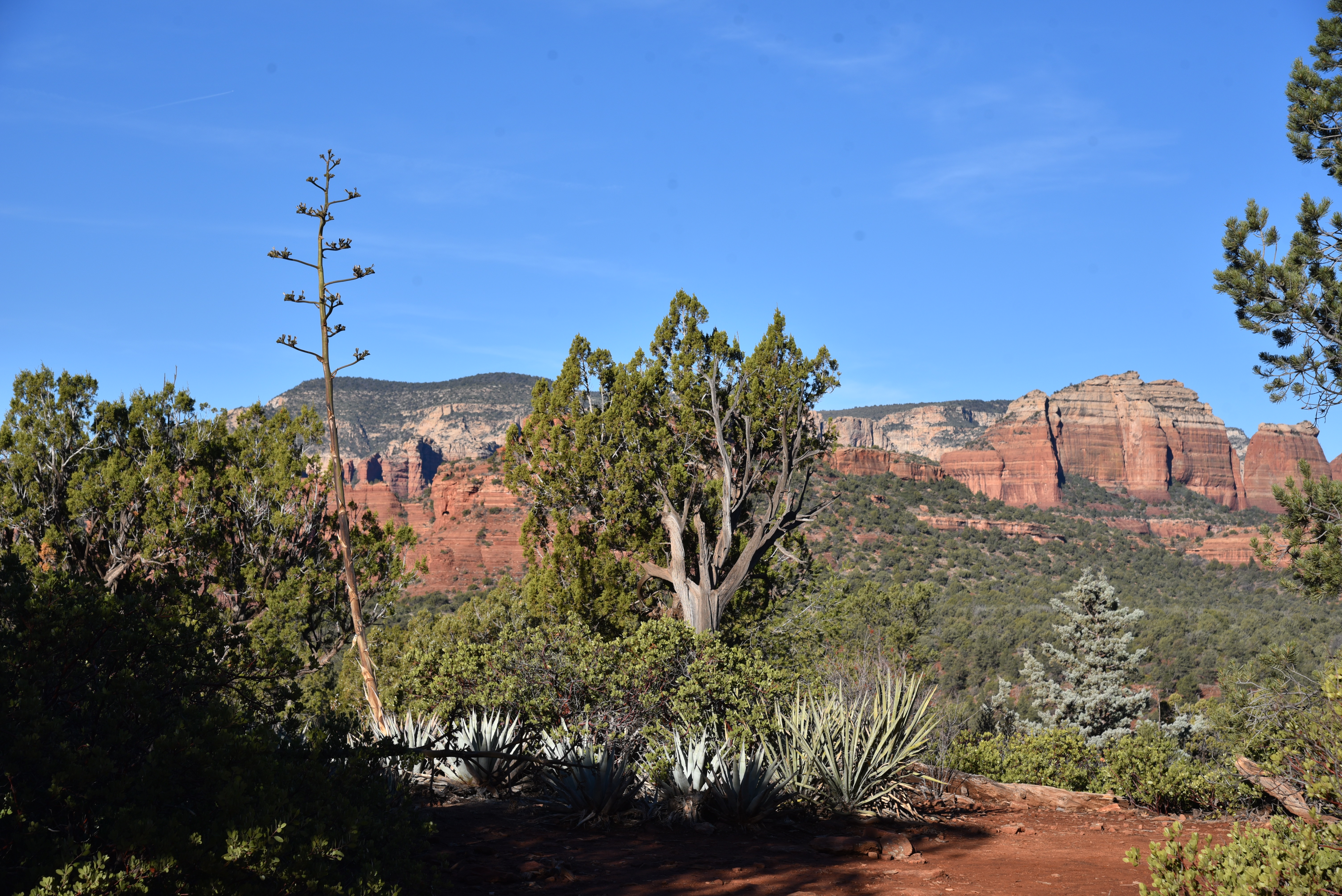
Mountain vista on Chuckwagon trail

Since my guests were fit but not really hikers, we took the short route beginning at the Mescal trailhead one of the four best ways to access the trail including the free Sedona Shuttle service.  
Cockscomb (L) and Doe Mountain

We arrived at 7:30 a.m. and scored one of the last open parking spaces.  Trail traffic along the first well-signed mile which follows the Mescal and Chuckwagon trails was constant, often coming in fits and spurts of small groups.  Bottlenecks begin where the route gets steeper, ascending uphill on rough cut sandstone staircases. About 0.2-miles before the bridge where the route crosses into the wilderness area, traffic slows to a near standstill as hikers meet a fork with one leg heading to the space below the arch and the other to the final stairs to the top. 
Crowd-free Devil's Bridge--18 years ago.

On weekends, we’re talking an elbow-to-elbow scenario of chatty, awestruck hikers.  It’s not the ideal experience for some, but anybody who ventures here ought to know that and shouldn’t expect solitude.  Having been there and done that, I decided to opt out of the line that was  tantamount to those at major theme parks but without the turnstiles. I waited in a cypress-shaded alcove with a nice family visiting from Europe while my friends earned their check mark, some fabulous photos, and a couple of new friends.


LENGTH:

From the Mescal Trailhead:  4 miles roundtrip

From the Dry Creek Vista Trailhead: 5.8 miles round trip

From Devils Bridge Trailhead:  1.8 miles roundtrip

RATING: moderate

ELEVATION: 4,500 – 4,910 feet


GETTING THERE:


SEDONA SHUTTLE--preferred method!

Service to Mescal and Dry Creek trailheads.

https://sedonashuttle.com/


DEVIL’S BRIDGE TRAILHEAD:

From the State Route 179/89A traffic circle in Sedona, go 3.2 miles west (toward Cottonwood) on SR 89A  to Dry Creek Road. Turn right and continue 2 miles to the turn off for Forest Road 152 on the right. Follow FR152 past the Dry Creek Vista trailhead for about a mile to the signed Devils Bridge parking area. The road beyond Dry Creek Vista is very rough. A high clearance/4x4 vehicle is required. There are no facilities or fees.


DRY CREEK VISTA TRAILHEAD:

From the State Route 179/89A traffic circle in Sedona, go 3.2 miles west (toward Cottonwood) on SR 89A  to Dry Creek Road. Turn right and continue 2 miles to the turn off for Forest Road 152/Dry Creek trailhead on the right and continue a short distance to the parking area. There’s a restroom at the trailhead. No fees.


MESCAL DAY USE TRAILHEAD:

From the State Route179 /US89A traffic circle in Sedona, go 3 miles west on 89A (left, toward Cottonwood) to Dry Creek Road (Forest Road 152C), turn right and continue 2.9 miles to Long Canyon Road (Forest Road 152D), turn right and go 0.2 mile to the trailhead on the left. There’s a restroom at the trailhead. No fees.


INFO & MAP:

Coconino National Forest

https://www.fs.usda.gov/recarea/coconino/recarea/?recid=55292

Tuesday, January 9, 2024

Vulture Mountain Ruins

VULTURE MOUNTAIN RUINS

Vulture Peak viewed from BLM 9052

Surrounded by an eclectic sampling of Arizona’s 194 named mountain ranges, The Vulture Mountains occupy a space rich in natural resources and human history. 

Hieroglyphic and Wickenburg Mountains view

The crescent-shaped range is comprised of a string of mounds 29 miles long and 13 miles wide located a dozen miles southwest of Wickenburg at the edge of Maricopa County.  
Hikers admire a twisted saguaro on BLM 9052

The Hassayampa River, a roughly 100-mile-long desert waterway that originates near Prescott and flows south, mostly underground, to merge with the Gila River, marks the eastern extent of the range. 
Saguaros dot a ravine in the Vulture Mountains

Its highpoint, 3,658-foot Vulture Peak, serves as Wickenburg’s most iconic land feature and the axis around which a cluster of defunct mining operations orbit.  
Hike begins with a crossing of the Hassayampa River

A network of Bureau of Land Management roads that are open to hikers, equestrians, and motorized use, provide access to the mineral-rich backcountry. 
Relics of mine ops in the Vulture Mountains

The main access point for exploratory adventures is by way of Gates Road in the community of Morristown.  The paved part of the road dead ends where Little San Domino Wash spills into the Hassayampa River.  

Relics protected by the Antiquities Act


From there, trail users may hike or drive across the usually dry floodplain to a gate where BLM road 9054 serves as entree to miles of dirt roads.  

Packrat middens are plentiful along BLM 9054

The best thing about hiking here is the joy of discovery.  Every road and side trail holds new vistas, natural arches, and points of interest, so there’s no bad plan.  Just pick a road and go.  One outing to try uses the clearly signed roads 9054 and 9052.

From the entry gate at the river, 9054 heads uphill, passing by the first of many optional side trips to an old mine site.  Mountain vistas make their first appearance at the top of a knoll with jaw-dropping looks at the Hieroglyphic and Wickenburg Mountains to the east, the Date Creek and Weaver Mountains to the north and the Bradshaw Mountains on the far northern horizon.

Washes feed into the Hassayampa River

Hikers trek BLM 9052

As the undulating route delves deeper into the boondocks, the distinctive forms of Vulture Peak and 3,044-foot Caballeros Peaks stand out to the northwest standing high above a cholla and saguaro studded landscape. 

Date Creek and Weaver Mountains to the north

At the two-mile point, this trip heads left onto road 9052, gaining and loosing elevation steadily.  At the 2.9-mile point, road 9052 veers left at a large white tank, then heads downhill and crosses a couple of washes before heading up yet again to meet an array of roadside mining detritus.  These minor prospects might have been the spawn of a nearby major mine operation.  The Vulture Mine and its companion Vulture City community was the hub of gold and silver extraction from 1863-1942. The core operation and a smattering of pick-and-shovel prospects mined the surface gold that was easily extracted by hand from exposed late Cretaceous pluton of quartz porphyry that shed bits of precious minerals in flakes, nuggets, and dust. 

Serial misfortunes including mismanagement, low gold prices, and high overhead caused sporadic closures and ownership changes until production in the area dribbled to a halt 1942. Some residual mineral extraction happened during World War II and limped into the 1960s when lingering deposits of copper, gold and lead were pulled from tailings and open shafts.

The abandoned Vulture Mountain mine sites had names that underpin their mysterious pasts. Details of the yields and histories of the Newsboy Mine, Montezuma Mine, Queen of Sheba Mine, El Tigre Mine, et al are buried in dusty boxes full of decades old claims.  

Artifacts near a mine prospect

Only the

Vulture Mine retains a semblance of its former glory. The site is now a privately owned tourist venue that preserves the dream of pulling riches from the desert. The lesser wildcat strikes live in comparative obscurity along ragged dirt roads in the hills above the Hassayampa River.  There’s little left to mark many of the small prospects.  Discarded cans, rotting wood planks, rusty nails and tailings scattered among chunks of quartz and metamorphic rocks crusted with brilliant blue green chrysocolla, a soft mineral associated with copper ore.

Gate at the Hassayampa River

When visiting historic sites, it’s important to help protect them. Federal law states that it is illegal to remove any artifact 50 years-old or older from public lands  (36 CFR 800,Title 18: Theft and Destruction of Government Property, the 1906 Antiquities Act, and the National Historic Preservation Act (NHPA) of 1966). An artifact is defined as anything made, modified, or used by humans. That would include cans, bottles, bricks, nails, tools, weapons, etc. When in doubt--leave it!  The historic artifacts link below helps identify common sightings.

Vulture Mountain scene on BLM 9054

At a spot along road 9052 that was probably a favorite lunch break hangout, dozens of rusted cans, crumpled metal, and sun-bleached wood litter a hillock overlooking the expanse of the Hassayampa Basin. To the southwest, the silhouette of the Harquahala Mountains rise to 5,681 feet above the flatlands filling the skyline.

Enjoy the discovery, but leave as is.


It’s easy to see why work wary miners would choose this serene locale to kick back with a can of beans after a long day of digging leaving behind relics for us to ponder.

LENGTH: 8.3 miles (to the lunch miner lunch spot and back)

RATING: moderate

ELEVATION: 1,767– 2,229 feet (1,225 feet of accumulated elevation change)

GETTING THERE:

From Phoenix, go north on Interstate 17 to State Route 74 (Carefree Highway).  Take SR 74 west (toward Wickenburg) for 30 miles to U.S. 60. Turn left and go 0.8-mile on U.S. 60 to Gates Road at milepost 121, turn right and continue 2.3 miles to the trailhead at Little Domingo Wash. Do not park within a quarter mile of the livestock water tank and respect private property in the area. Access roads are paved.

FUN HISTORY & SCIENCE:

http://docs.azgs.az.gov/OnlineAccessMineFiles/S-Z/VultureMaricopa273-2.pdf

HISTORIC ARTIFACT IDENTIFICATION GUIDE:

https://www.ntc.blm.gov/krc/system/files?file=legacy/uploads/22015/HistoricArtifactIDGuide.pdf


Monday, December 11, 2023

Elmore Wash

ELMORE WASH

Wickiup Mesa Trail System

Elmore Wash trail in Coconino National Forest

Access to Arizona wilderness areas is a mixed bag of easy walk-ins from paved suburban roads. (Munds Mountain Wilderness in Sedona) to miles of driving on white knuckle two tracks in the middle of nowhere (Bear Wallow Wilderness near Hannagan Meadow). There’s also a middle ground. 

Elmore Wash trail is well signed

The Wickiup Mesa Trail System located in the adjacent communities of Rimrock, McGuireville and Montezuma Lake offers a hikeable link between Interstate 17 and two of Central Arizona’s most popular wilderness destinations. 
Trailhead on Forest Road 618

The 6.5-mile, non-motorized trail system in Coconino National Forest east of Sedona opened in 2018 through a partnership with the forest service, Yavapai County and the Beaver Creek Trails Coalition.  Situated on 700 acres of thorny grasslands and juniper woodlands the system provides seamless access to the Wet Beaver and West Clear Creek Wilderness areas.
Cedar Knoll trail grasslands


The singletrack trail system is anchored by the 2-mile Sunset Loop. Tendril spurs connect to community access points, OHV trails, a scenic ledge overlooking the Montezuma Well heritage site and the Elmore Wash trail which makes a straight shot toward the wilderness.

Sunset Loop anchors Wickiup Mesa Trails

Trailheads in the Rimrock community and along Forest Road 618 make it easy to plan out-and-back day hikes or longer trips by connecting with the Bell, Walker Basin or West Clear Creek trails.  From the Forestglen trailhead at the south end of the Rimrock community, the hike begins on the Cedar Knoll trail.  This easy-rated 0.6-mile segment twists through sunny pastures dotted with yucca and junipers. 

Mesquite trees clutter around Elmore Wash trail

Big views of the Munds Mountain Wilderness and Sedona’s red rocks front barely-there glimpses of the San Francisco Peaks to the north. 
Forestglen trailhead in Rimrock

At the Sunset Loop junction, the route veers east (go right) taking on a slightly more rugged character as it gradually leaves the open terrain behind and ascends between tree-covered knolls. 
Looking west on Elmore Wash trail

The 0.8-mile leg ends at the Elmore Wash trail junction where wilderness mountains hover over the gorge of Walker Basin.  Although it’s rated moderate in difficulty, the Elmore Wash trail delivers a decent workout with a rollercoaster series of ups-and-downs. 
Sign with historical info at the trailhead

The trail alternates between dips and crosses of the eponymous wash and highpoint vistas of the Bradshaw Mountains to the west. 
View of Bradshaw Mountains from Elmore Wash

The hike in an immersive experience into the Middle Verde Watershed that’s part of a 4.2-million-acre ecosystem that includes roughly 500 miles of perennial streams that feed into the Verde River which provides a substantial amount of the surface water delivered to the Metro Phoenix area.
Snow-capped peaks seen from Cedar Knoll

As the trail nears its terminus at Forest Road 618, tree cover increases with a dusting of pinyon pine joining the mix of mesquite, scrub oak and sharp-spined Crucifixion-thorn.  At the 3.3-mile point, a kiosk with map and historical information marks the border of the Wickiup Mesa Trail System.  Across the road, though, the hike may be extended with a mile-long walk on Forest Road 9201C that leads to the Walker Basin Trail, a difficult 8-mile primitive route into the drainages between Wet Beaver Creek and West Clear Creek. For an easier add on, the 11-mile Bell Trail, which leads to swimming holes and amazing geology, begins 3 miles north on FR 618.  About 4.5 south of the FR9201C turnoff for Walker Basin, the West Clear Creek Trail may be accessed by following signs to the Bullpen Ranch trailhead.

Junctions feature map signs

Old trough on Elmore Wash trail

LENGTH: 6.6 miles roundtrip (out-and-back hike)

RATING: moderate

ELEVATION: 3,631 – 3,853 feet (731 feet of accumulated elevation change)

GETTING THERE:

FORESTGLEN TRAILHEAD:

From Interstate 17 north of Camp Verde, take the McGuireville exit 293 and veer east (right) onto Beaver Creek Road (County Road 77). Continue 1.8 miles and veer right onto Montezuma Ave. Go 1.3 miles to Cliffside Trail, turn left and follow the winding road 0.9 mile to Geronimo Road, turn right and drive 0.4 mile to Forestglen Road. Turn right and continue 0.3 mile to the trailhead at the intersection of Redrock Road. Roads are paved.

FOREST ROAD 618 TRAILHEAD:

From Interstate 17 north of Camp Verde, take the Sedona-Oak Creek exit 298 for State Route 179.  Turn east (right) at the bottom of the ramp and continue 4.5 miles on Forest Road 618 to the Walker Basin TH sign and the trailhead on the right.  There is limited parking along the road and on adjacent FR 9201C. Roads are maintained dirt and gravel.

There are no fees or facilities at either trailhead.


Tuesday, December 5, 2023

Maricopa Trail to Camp Creek Falls

MARICOPA TRAIL SEGMENT 22

BARTLETT DAM ROAD to CAMP CREEK FALLS

Camp Creek in Tonto National Forest

Over its 315+-mile course, the Maricopa Trail unfurls its tendrils to link county regional parks, suburbs, urban public spaces, canals, historic paths, and remote stretches of national forest.  To hike the full loop is tantamount to a walking tour of the Valley’s multi-faceted landscape. 

Mountain vistas on the Maricopa Trail

The epic non-motorized route that circles the Valley broke ground in 2007 in the Spur Cross Ranch Conservation Area, and the main loop was completed in 2018. 
Hikers in the Camp Creek Falls grotto

The trail continues to improve, evolve, build connectivity, and add length as it adapts to accommodate growing community interest and enthusiastic hiker, biker, and equestrian users.  Built to encourage hikers of every ilk to get outdoors, the route’s many trailheads and neighborhood access points make it simple to hop on and off the trail from anywhere in the Valley, with two notable exceptions: the Spur Cross to Bronco and Bronco to Granite Mountain segments. 
Segment 22 of the MT is wide and well signed

Where the northernmost segments of the trail pass through Tonto National Forest, there’s an average of 13 miles between drive up trailheads. And, for seasoned, well-prepared trail users, that’s where the best stuff resides.  Segment 22 which runs for 16-miles from the north border of Scottsdale’s McDowell Sonoran Preserve to the Bronco trailhead in Tonto National Forest was among the last passages to be completed. 
The trail heads downhill on brushy foothills

Rugged terrain, scoured washes, nasty back roads and stubborn rock contributed the difficulty encountered by trail construction crews. Then, in September and October 2020, the 15,000+-acre Sears Fire took a toll on several miles of the segment located roughly 20 miles northeast of Cave Creek.  
Hazy Mt. Ord (center horizon) viewed from the trail

Within months, work crews restored the damaged trail, fixing drainages and stabilizing eroded slopes.  While the moderately difficult entire 12.6-mile Segment 22 hike can sound intimidating for some, there’s an option for an out-and-back day hike that includes a visit to one of the Valley’s most beloved natural wonders.
Morning vista on the Maricopa Trail

Beginning along Bartlett Dam Road, Segment 22 heads north through a shadeless expanse of catclaw and saguaros.  The path briefly traces a powerline, but then veers east into wash-riddled backcountry with unobstructed mountain views.  The rocky domes of Kentuck Mountain (5,013 feet), Maverick Butte (4,870 feet), Humboldt Mountain (5, 204 feet)and St, Clair Mountain (3,252 feet) populate foreground with Mount Ord (7,128 feet) and the cloud bumping Mazatzal Range standing high over the Verde River Basin in the distance. 

The Maricopa Trail crosses sandy Blue Wash

The trail twists downhill, clinging to foothills and stony edges landing hikers at the sandy corridor of Blue Wash at the 3.4-mile point. 
Where the MT crosses Bartlett Dam Road

From a barbed wire and wood gate, an American flag planted on a prominent knoll with a Fresco Mines claim sign across the wash marks the beginning of a side trip to Camp Creek Falls. 
Interesting rock formations throughout the hike

The side trip veers left from the Maricopa Trail and follows the glassy slip of Camp Creek to a box canyon where a perennial stream of water spills about 20 feet over solid rock into a shallow plunge pool.  Desert waterfalls are rare enough, but this one in its tiny grotto fringed by cottonwoods, willows and reeds is a real gem.
Camp Creek leads to a desert waterfall

 
Flag (center) on knoll marks the falls side trip

The spring-fed fount is a critical water source for the deer, javelina and myriad little critters that live in the surrounding desert and makes for a scenic stop over for both long-distance treks and short day hikes on the Maricopa Trail.
The spring-fed waters of Camp Creek Falls

SUPPORT THE TRAIL:


If this wild and wonderful segment of the Maricopa Trail has inspired you, please consider supporting the effort by attending the Prickly Pedal Bike Race, the trail’s main fund-raising event.

Prickly Pedal on the Maricopa Trail will run 36 miles from Cave Creek to Lake Pleasant in Peoria.

The annual event is produced by Aravaipa Rides to benefit the Maricopa Trail + Park Foundation which funds trail building and maintenance projects.

Heads up that trail closures will be in effect along the racecourse.

RACE: 8:30 (pre-registration required)

EXPO & AFTER PARTY: 11 a.m. – 3 p.m.

Public is invited to enjoy the finish line party with beer garden, exhibitors, music, and fun.

https://pricklypedal.com/


LENGTH: 7 miles round trip, out-and back to the falls

RATING: moderate

ELEVATION: 2,833 – 3,303 feet (793 feet of elevation change)

GETTING THERE:

SOUTH TRAILHEAD

BARTLETT DAM ROAD-WILDCAT HILL OHV PARKING:

From Loop 101 in Scottsdale, take the Pima/Princess Drive exit 36 and go 13 miles north on Pima and turn right on Cave Creek Road.  Continue 4.1 miles to Bartlett Dam Road, turn right and go 0.4-mile to a dirt road on the right 0.1-mile past the Tonto National Forest ranger station.  Turn right and park along the dirt turn outs. Follow the Maricopa Trail signs to cross Bartlett Dam Road and continue north.

TONTO NATIONAL FOREST CAVE CREEK RANGER STATION:

40202 N. Cave Creek Road, Scottsdale.

May be closed on weekends and holidays.

Use the 0.2-mile connector that starts at the big Maricopa Trail kiosk.

INFO & MAPS:

https://www.maricopacountyparks.net/park-locator/maricopa-trail/