Find A Trail. Start Your Search Here:

Wednesday, July 31, 2019

Berry Road

BERRY ROAD
Berry Road is an apt moniker for this Mormon Lake hike
A drive along Lake Mary Road that runs between Flagstaff and State Route 87 at the edge of the Mogollon Rim south of the community of Happy Jack is a dramatic tour of  Arizona’s plateau lakes region and the high-country woodlands of Coconino National Forest. A particularly scenic section passes by Upper and Lower Lake Mary and Mormon Lake.
Mormon Lake is a sometimes marsh, sometimes lake
At roughly 2-miles across, Mormon Lake is Arizona’s largest natural lake. Fed mostly by snow melt, the lake’s surface area vacillates between a substantial pool and swampy swales depending on seasonal precipitation. This year has been a pretty good one for the lake. Even now, in late summer, the watery basin is a collection of deep ponds, reedy puddles and emerald wetlands.
Berry Road traces the cliffs below Lake Mary Road.
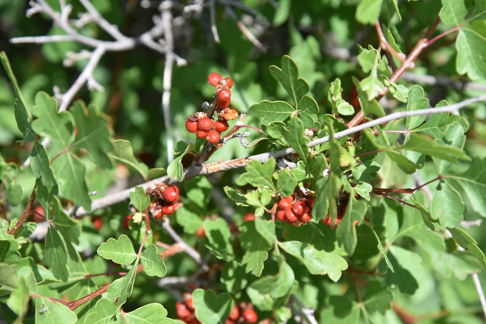
Wildlife feed on skunk bush fruits that grow along Berry Rd.
The easiest way to view this natural wonder is to make a stop at one or both of the scenic lookout points on Lake Mary Road. The northern most overlook near milepost 322 that's named for wildlife conservationist  Douglas C. Morrison, Jr., sits on a rise at the lake’s northeast corner while a second point two miles to the south offers dizzying lake vistas from the top of vertical cliffs of volcanic stone.
Both sites have interpretive signs that describe land features and wildlife to look for while visiting the area. If you have a sharp eye, you might notice a rough road below the lookouts that traces a ledge above the lake.  This is the old Lake Mary frontage road—better known as Berry Road.
A grasshopper blends in with grasses around Mormon Lake.
Trail visible below the north roadside overlook site.
If you’re intrigued by the cliff-top vistas and want to get a closer look; take this low road.
The easy trek begins at a gate where the old road has been closed to motorized use. Open to hikers, equestrians and mountain bikers, the  route offers excellent opportunities for wildlife viewing and exploring a bounty of fruit-bearing native plants.
Oak trees and fruit-bearing shrubs line Berry Road.
It’s not called Berry Road for naught.  
The hike follows an old frontage road above Mormon Lake
The crumbling byway—with remnants of the chrome-colored paint that marked the median-- reads like a lush wildlife buffet. Arizona walnut trees, Utah service berry, wax currents, skunk bush and Blueberry elders drip with fruits in late summer.  The abundance of wild foods attract swarms of wildlife.  If you walk quietly and gaze over the lake, you’re almost certain to see waterfowl, hawks, pronghorn and elk foraging among bull rushes.
A bumper crop of wax currents ripen along Berry Road.
Late summer and early fall are the best times to observe Rocky Mountain elk. For a primer in how best to observe these impressive beasts in their native habitats, sign up to attend the Arizona Game and Fish Department viewing workshop at Mormon Lake Lodge on August 17th.
A herd of Rocky Mountain elk wallow in Mormon Lake.
When hiking Berry Road, it’s handy to have a pair of binoculars in tow to spot the shy Great blue herons, egrets and osprey that are quick to scurry into cover when startled. 
Between shady stands of Ponderosa pines, Gambel oaks, junipers, cottonwoods and aspens, great views of Mormon Mountain that rises to 8,456 feet above the lake’s western shore fill the horizon.  To the northwest, the San Francisco Peaks appear as a hazy purple silhouette.
At the 1.4-mile point, the road bumps up against stony escarpments below the south lookout site. Here, a jungle of Arizona Walnut trees brushing against columns of basalt cinch the road and clouds of pollinators hover around dozens of wildflower species including poison milkweed, globemallow and wild geraniums that sprout from cracks in the pavement.
View from the south overlook point on Lake Mary Road.
Deer, birds and rodents feast on Utah serviceberry fruits.
The first substantial group of aspens appear at around the 3-mile point where the north lookout site is just barely visible ahead on a prominent ridge above the road.
Berry Road is open year-round for non-motorized use.
Across the pond, lake-side homes and structures of the major recreation hub surrounding Mormon Lake Village peek out from thick tree cover. This popular summer getaway destination is a huge draw for visitors interested in the area’s boating, fishing, picnicking, camping, hiking and eclectic mix of restaurants, trail ride outfitters, cabin rentals and events. It’s a worthy post-hike side trip, too.
Reedy wetlands at Mormon Lake attract wildlife
Pollinators swarm around poison milkweed plants.
San Francisco Peaks seen from Berry Road at Mormon Lake
Mormon Mountain looms above the lake's west shore.
What’s left of the old frontage road fades into a murky contour of the lake just beyond the north lookout site.
You may choose to follow the weed-encroached path a little farther, but it’s best to leave this feral terminus and its fruits and nuts to the birds and beasts and backtrack to the lodge for pizza and beer instead. 
An Arizona walnut tree shades Berry Road at Mormon Lake
 
Wild geranium grow in tangled clusters along the trail.
Aspens frame views of Mormon Mountain.
Squirrels love the Arizona walnuts that grow on Berry Road
LENGTH: 6.4 miles out-and-back
RATING: easy
ELEVATION: 7,182 – 7,031 feet
GETTING THERE:
From Flagstaff, go 24.8 miles south on Lake Mary Road (Forest Road 3) to an unsigned road on the right  just past milepost 319 where there’s a sign that reads “no vehicle turnaround”.  Low clearance vehicles should park along the pullouts here, otherwise drive the road 0.2-mile, cross a cattle guard, turn right at a fork, continue 0.1-mile uphill and park near a locked gate.
INFO:  Coconino National Forest
Arizona Game and Fish Department  Elk Viewing Workshop: August 17, 2019
Arizona Watchable Wildlife Experience
Mormon Lake Lodge
-->

Wednesday, July 24, 2019

Route 66 Ghost Roads Convergence

Route 66 Ghost Roads Convergence
A spring house on the Route 66 Ghost Road trail
Historic Route 66 embodies a uniquely American sort of inertia: constantly changing, evolving and adapting to innovations while respecting its roots.
The Mother Road that ran for 2,448 miles between Chicago and Los Angeles is no longer the arterial travel corridor is was from the 1920s to the 1960s, but its legacy has been curated in stretches of drive-able pavement and backwoods “ghost roads” accessible only by way of bike or foot travel.
In Northern Arizona, the iconic road was re-routed several times before being replaced by Interstate 40. Today, bits and pieces of the decommissioned road have been repurposed into scenic driving tours, bike trails and walking paths that preserve its heritage and crumbing imprints on the landscape.  One interesting location to explore on foot is where remnants of the road’s 1921, 1931 and 1941 alignments converge north of Interstate 40 in the tiny community of Parks.
Three alignments of Route 66 meet at this point on the trail.
Hiding in plain sight along a motorized stretch of Old Route 66 about halfway between Flagstaff and Williams, in Kaibab National Forest, a dusty pullout and information kiosk mark the beginning of an easy stroll at the juncture of three ghost roads.
Plants take root in the abandoned 1931 alignment of Rt. 66
Located not far from the Pines General Store Deli & CafĂ© and postal annex that’s been around since 1906, the who-knew trailhead surrounded by a fading log-pole fence directs hikers onto a mile-long segment of the 1931 alignment--the northernmost vestige on the hike. 
Trailhead sign shows the evolution of Route 66 near Parks.
A few yards to the south, the 1921 alignment is a barely-there dirt two-track that’s slowing being reclaimed by the forest. South of the vanishing dirt passage, cars whiz by on paved Old Route 66 (1941- 1964) while the hum of vehicles on Interstate 40 betray the location of the freeway that diluted Route 66’s status as a major thoroughfare and gateway to the Southwest down to a recreational curiosity.
The ghostly footprint of the 1921 alignment of Route 66
The 1931 road-turned-hiking-trail makes a straight shot through pine-oak forests and weedy meadows.  
Calliopsis grown in drainages along the trail.
At the start of the hike, part of the road appears to have been bulldozed away.
A decommissioned segment of Rt. 66 is now a hiking trail.
Piles of broken concrete along the north edge of the route soon give way to patches of intact pavement in varying degrees of decay. Underfoot, the remains of the road include a montage of blacktop, concrete and a pinkish pebble conglomerate that hint at the challenges of Depression-era road maintenance.

A Depression-era culvert spans a drainage on the trail.
 
The route passes through pine-oak woodlands in Kaibab NF.
About a quarter-mile in, a culvert bearing the clean lines and subdued edges typical of 1930s design spans a drainage area replete with wildflowers.
Gate at trail's end.
Beyond that, near where a wall of basalt bolsters the road’s edge, there’s a stone spring house that had been used as part of a defunct forest service camp. 
The trailhead is in a pullout on the 1941 alignment of Rt.66
A few steps past the spring house, the trail passes a wooden gate where a pair of culverts--one from 1931 and the other from 1941—mark the merger point of the three ghost roads that are the fading predecessors of the modern-day interstate highway system.
An old forest service camp spring house along the trail.
Yellow sweet clover grows along the edge of the trail.
The 1931 alignment is composed of various materials
LENGTH: 2 miles out-and-back
RATING: easy
ELEVATION: 7,015 - 7,171 feet
GETTING THERE:
From Interstate 40 about 13 miles west of Flagstaff, take the Parks exit 178 and go 0.4-mile north to Old Route 66. Turn right and continue 0.4-mile to the trailhead on the left.
INFO: Kaibab National Forest
--> -->

Monday, July 22, 2019

See Spring

SEE SPRING
Water rushes from a crevice at the head of See Spring
On the jagged cliffs below the Mogollon Rim, dozens of springs dispense water that filters through the porous limestone escarpments.
The hike begins with an easy crossing of Christopher Creek 
The springs range in flow from steady trickles that drain into green seeps to icy founts that gush from solid rock, carving gullies and fostering thick forests.
  See Spring is one of the later. Its location half-a-mile off the See Canyon Trail along Christopher Creek in Tonto National Forest twenty miles east of Payson makes it a popular choice for a short day hike or add-on to the 2.5-mile mile artery route that climbs over 1700 feet to the top of the Rim.
There’s a local hiker adage that claims when trekking See Canyon, all you see is the canyon. This is mostly true, but, oh, what a canyon it is to behold. 
New Mexico locust grow in dense thickets on the trail.
Dense woodlands shade the See Canyon Trail
Right out of the chute, the trail delivers a rich palette of sights and sounds plus enough challenge (or not) to satisfy a full gamut of hiking styles. You don’t have to walk very far before becoming immersed in the perennial flow of Christopher Creek and the lush woodlands that thrive in its moist environs. 
Christopher Creek is a main feature of the trek.
Boxelder trees love the moist environs near See Spring
The journey begins with a brief walk on the Highline Trail. From the trailhead, follow the footpath to where a pair of white diamond symbols tacked to trees indicate where the route makes an easy crossing of the creek. On the opposite bank, walk a few yards and veer left at the See Canyon Trail junction. The next half-mile traces the stream through a mix of meadows and forests of New Mexico locust, boxelders and Ponderosa pines. Beneath the leafy canopy, healthy tangles of canyon grape vines mingle with insidious clumps of poison ivy--leaves of three, let it be.
Canyon grapes flourish in moist areas on the trail.
It’s smart to wear long pants on this hike to avoid getting an itchy rash.
Mountain vistas are sparse, but water features are plentiful
The path crosses several rocky drainages as it gently gains elevation to reveal glimpses of Promontory Butte, a major Rim land feature.  At the 0.8-mile point, head right at the See Spring Trail junction where the half-mile spur path swerves away from the creek and begins a moderate climb.  
Bigtooth maples filter sunlight on See Spring Trail
The “all you see” adage really hits home here as thick stands of Bigtooth maples, Gamble oaks, Alligator junipers, Arizona walnut and soaring Douglas and white firs choke the trail into a shady, slim passage obscuring all but sky and vegetation.  A few sets of switchbacks mitigate the 400-foot ascent that lands hikers in an enchanting natural water park setting.
Tree cover on the See Spring Trail
Roughly 1.3 miles from the trailhead, the first signs of the See Spring conglomerate of waterworks appear as jumbled ravines funneling crystalline streams.  Follow the faint footpaths another 0.2-mile and you’ll arrive at the spring source where water pours from rock crevices all around.
Golden-beard penstemons add brilliant color to the trek.
The splashy rhythms of water rushing over mossy boulders and flattened ferns complemented by bird calls and rustling leaves combine for a calming culmination of short trek with much to see. 
Scampering lizards are constant companions on the trail
See Canyon-See Spring junction
You're never far from water on this Mogollon Rim classic
See Canyon Trail traces Christopher Creek
Icy water spills from See Spring
Poison ivy. Leaves of three, let it be.
LENGTH: 2.6 miles roundtrip (5 miles with See Canyon Trail)
RATING: moderate
ELEVATION:  6106 – 6725 feet (7860 feet with See Canyon Trail)
GETTING THERE:
From Payson, go 20.2 miles east on State Route 260 to the Christopher Creek Loop exit, turn left and continue 1 mile to Forest Road 284 (across from the Tall Pines Market), turn left and go 1.6 miles to the trailhead. Access road is good dirt/gravel suitable for all vehicles. There’s a restroom at the trailhead.
INFO: