Find A Trail. Start Your Search Here:

Thursday, March 8, 2012

Lost Dutchman State Park guided hikes

Medicinal plants of the Sonoran Desert hike
Apache Junction
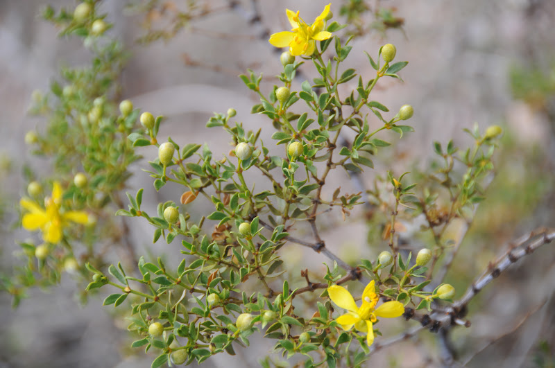
creosote

There’s always something fun going on at Lost Dutchman State Park, and the month of March is jam-packed with events, hikes and programs.  This week I participated in a guided hike called Medicinal plants of the Sonoran Desert.  Following parts of the park’s Treasure Loop, Prospector’s View and Jacob’s Crosscut trails, volunteer hike leaders stopped at various shrubs, trees and flowers explaining each plant’s medicinal and food value attributes.  For instance, did you know that parts of the creosote bush can be used to reduce symptoms of arthritis, asthma and certain bacterial and fungal infections?  Or, that mesquite tree beans make flavorful, nutritious flour and that a tea made from its leaves can sooth sunburn, rashes and sore throats?  Here’s a sample of what’s on deck in the coming weeks, check the park web site for details:
March 14: Getting to know the birds around you.
March 16: Star Talk with astronomer Bill Dellinges
March 21: Geology Hike
March 24: Reptiles & Amphibians program

jojoba
LENGTH:  3.5 miles
RATING:  easy
ELEVATION: 2,000' – 2,500'
DOGS: must be on leash, pack out droppings
DISTANCE FROM PHOENIX: 40 miles
GETTING THERE:
From Phoenix, go east on US60 to exit 196 for AZ88/Idaho Road.  Turn left and follow Idaho Road
2.3 miles to AZ88/Apache Trail.  Turn right and continue 4.9 miles to the park entrance on the right.
FEE: $7 daily fee per vehicle (includes guided hikes)
FACILITIES: restrooms, water, camping, picnic tables, visitor center

INFO:  480-982-4485
http://azstateparks.com/Parks/LODU/index.html
MORE PHOTOS: 

Monday, March 5, 2012

WOLVERTON MOUNTAIN-WHITE SPAR PEAK

WOLVERTON MOUNTAIN-WHITE SPAR PEAK
City of Prescott-Prescott National Forest
Summit of White Spar

In Prescott-- the town where the streets have multiple, morphing  names--the same confusing moniker-muddling  applies to  local trails and geographic landmarks.   Case in point: the Wolverton Mountain Trail.  This lovely, pine-chaparral trail is also dubbed the Sierra Prieta Trail, forest trail #9415 and is now also part of the City of Prescott  Circle Trail System.  Confused?  Don't be—the trail is meticulously signed, heavily-traveled, and not-too-far from civilization, so there's little chance you'll loose your way.
Snow on Aspen Creek trail: March 3, 2012
Anchored by two easy-to-access trailheads, we chose to begin the hike at the Aspen Creek lot on Copper Basin Road.  From here, the hike begins across the road on trail #48 (Aspen Creek Trail). Hike steeply uphill 0.4 mile to  the turn off for “9415” (Wolverton Mountain Trail) at the second junction.   Note that the “9415” signs are located a few yards past the intersections---so make sure you locate them before making any turns.  Along the way, two side trips make for interesting exploration.  First up--just past the a gate near mile 1.2--there's a short 0.5 mile dirt road heading left that leads to a weather station below a high ridge on Wolverton Mountain where nice views of Prescott's  Thumb Butte area shine below.  The second detour is a highly-recommended  trip up to White Spar Peak (a.k.a. Quartz Mountain). At roughly 2.5 miles, turn right onto trail 9415A and follow a maze of old roads to a point just below the  top of the snowy-white quartz massif.  Here, it's easy to pick out informal footpaths that lead to the summit.  Hint---you should not have to scramble or use your hands to climb to the summit—if you find yourself doing so, locate an easier  route.  Well worth the extra effort, the hike up White Spar rewards with 360-degree views of  Flagstaff's  San Francisco Peaks, Bill Williams Mountain in Williams, the Verde River Canyon, and of course, the local lakes, woodlands and granite dells. We hiked this trail on March 3, 2012—a couple of days after a storm dusted the forests with a few inches of snow. Waning drifts in the south-facing canyons and a veil of frost on the peak made this trek all the more enjoyable.
Approaching White Spar (left) from Wolverton Mtn. trail

LENGTH: 5 miles one-way (7.6 miles with side trips)
RATING: moderate
ELEVATION:  5,600' -6,694'
FACILITIES/FEES: none
BEST SEASON: year-round, but best October – May
DISTANCE FROM PHOENIX: 118 miles one way
GETTING THERE:
WEST: Aspen Creek trailhead:
From the AZ69/89 junction in Prescott continue 1.25 miles west on 69 (becomes Gurley St) to Montezuma St.. Turn left (south) on Montezuma (turns into AZ89/White Spar Road) and go 1 mile to the light at Copper Basin Road.  Turn right and go 4.6 miles on  Copper Basin (turns to good dirt after 1.6 miles) to the trailhead on the right---signed Aspen Creek Trailhead. 
EAST: White Spar Campground trailhead:
From the AZ69/89 junction in Prescott continue 1.25 miles west on 69 (becomes Gurley St) to Montezuma St. Turn left (south)  south on Montezuma (turns into AZ89/White Spar Road) and go 3 miles to the parking lot on the left.  Trail access is south of the campground on the west side of  AZ89.
INFO & MAP: http://www.cityofprescott.net/services/parks/trails/?id=44

MORE PHOTOS:

Saturday, March 3, 2012

A striking desert passage of the Arizona Trail

ALAMO CANYON
Passage 17 of the Arizona Trail, Superior
Picketpost Mountain

For the first four miles of this undulating passage of state-traversing Arizona Trail, the imposing profile of Picketpost Mountain looms large on its eastern flank until the route's remote interior swallows the stony beast thus making way for spectacular canyon views.  Traveling south from Picketpost trailhead, the path begins as a mild walk in the desert but soon transitions into a roller-coaster-like hike through
Looking toward Superstition Wilderness
gullies, washes and moist drainages where mesquite trees provide what little shade there is to be had in this exposed backcountry.  Because of all the ups-and-downs, this moderate hike feels tougher than it is, so bring extra water and snacks to fuel the trek that ends at the northwest boundary of the White Canyon Wilderness.  Here, you can continue south on the Arizona Trail, Gila River Canyons passage #16  toward Tucson.

LENGTH: 11.5 miles one way
RATING:  moderate
ELEVATION:  2,360' – 3,800'
BEST SEASON: October - March
Mesquite shade

GETTING THERE:
Picketpost Trailhead:
From Phoenix, travel east on US60 to milepost 221—located just before the town of Superior  (if you reach Boyce Thompson Arboretum, you've gone  1.7 miles too far). About 0.4 mile past milepost 221, look for the signed turn off for Picketpost Trailhead (FR 231) on the right.  Turn onto this good dirt road and continue 0.2 mile to a “T” intersection  ---turn left (east) here and go 0.6 mile to the trailhead.
INFO:
Arizona Trail Association:
http://www.aztrail.org/passages/pass_16.html
Tonto National Forest, Globe Ranger District:
(928) 402-6200
White Canyon Wilderness, Bureau of Land Management

MORE PHOTOS:

Friday, March 2, 2012

New rating system for Valley hiking trails

Beware the “double black diamond” trails. 

The City of Phoenix and surrounding towns including Scottsdale, Glendale, Tempe and Fountain Hills, have adopted a new system of coding trail difficulty levels to better aid hikers in selecting routes that best match their abilities.
The system uses six color-coded symbols similar to those used for ski runs. They are:
WHITE DOT: easiest, flat, barrier-free, max 5% grade
GREEN DOT: easy, mostly smooth & wide dirt trails, max 10% grade
BLUE SQUARE: moderate, mostly smooth, variable width dirt with some unevenness, max 15% grade
BLUE DIAMOND: moderately difficult, mostly uneven dirt & rock, max 20% grade
BLACK DIAMOND: difficult, long , rocky segments with possible drops & exposure, loose, uneven rock, more than 20% grade
DOUBLE BLACK DIAMOND: extremely difficult, long , rocky segments with possible drops & exposure, loose, uneven rock, more than 20% grade, obstacles and excessive heat

The new rating system was unveiled on Feb 29, 2012 and will start popping up on area park web sites soon. Future plans also include adding the symbols to trail signs.

Monday, February 27, 2012

Prescott bird-watching hike

WATSON WOODS RIPARIAN PRESERVE
Ducks take flight in Watson Woods
Prescott
Birds flock to pools along Granite Creek 
A sign at the trailhead proclaims that Watson Woods has been designated an “important bird habitat” by the Audubon society.  This is an understatement.  Once a 1000-acre-plus stream side bosque of cottonwood, walnut and other moisture-loving plants along lower Granite Creek, the area was nearly lost to the ravages of modern development.  However, thanks to the efforts of the City of Prescott and Prescott Creeks (local watershed stewards) the woodlands are being restored.  Today, the preserve is a 126-acre bird-and-wildlife haven.  Even though it's located just yards off busy highway 69, the lush waterway boasts a bevy of natural wonders for your viewing pleasure.  A scenic interpretive trail guides hikers among restored wetlands, canopies of gigantic centuries-old trees, ponds and marshes.  Signs both at the trailhead and along the route describe the sights and chronicle on-going restoration efforts.
In addition to a sturdy pair of shoes for the dirt walkways, bring along a pair of binoculars (birds galore) and a hearty appetite for knowledge---you won't be disappointed. Also, for those who want to extend their hike, the preserve trail connects with adjacent Watson Lake Park, Lower Granite Creek trail system and the Prescott Peavine National Recreational Trail.

LENGTH: 0.5 mile one way
RATING: easy, educational
ELEVATION: 5,100'
KID FRIENDLY?: yes
DOGS: this is a sensitive riparian habitat, dogs MUST be on leash and all droppings packed out
HOURS: 7 A.M. - 10 P.M.
FEE: $2 parking fee
FACILITIES: port-o-potties (real restrooms planned for June 2012), picnic tables, maps
DISTANCE FROM PHOENIX: 112 miles one way
Red-winged blackbird 

GETTING THERE:
1626 Sundog Ranch Road in Prescott. From Phoenix, travel north on I17 to Cordes Junction  exit 262 for Prescott  AZ 69.  Turn west and go 32 miles on AZ 69  to Prescott.  Just outside of downtown, pass Walker Road and begin looking for Prescott Lakes Parkway---located across from the Prescott Gateway Mall where there's a huge Cadillac dealership. Turn right (north) on Prescott Lakes Pkwy and continue 1.7 miles to Sundog Ranch Road, turn right and go 0.2 mile  to Peavine Trail/Watson Woods Riparian Preserve parking area. HIKE: Follow the paved Peavine entrance trail for about 100 meters, pass the picnic ramada and turn left once you reach the cindered potion of the trail. The Preserve walk-in gate and kiosk are west of the large walnut tree.
INFO: 
City of Prescott
Site is managed by: Prescott Creeks, 928-445-5669

MORE PHOTOS:

Thursday, February 23, 2012

A water-themed hike near Black Canyon City

HORSESHOE BEND-SKYLINE SEGMENTS of the BLACK CANYON TRAIL
View of the Agua Fria River from Horseshoe Bend trail

Horseshoe Bend crossing
Along the Skyline trail
Just behind the Rock Springs Cafe (the “world-famous pies” place on I-17 near Black Canyon City), the Agua Fria River makes a U-bend around the defensive stone of Horseshoe Bar before continuing on its southbound, trickling meander.  It's here where two easy, open-to-the-sky segments of the 79-mile-long Black Canyon Trail (BCT) combine for a satisfying trek for both novices and expert hikers alike. Running from the Carefree Highway in Phoenix to near the town of Mayer in the Prescott National Forest, the course of the BCT has been in use since ancient times transitioning from Native American footpath, livestock driveway and wagon route to its current status as a hiking destination. The process of repurposing it into a multi-use recreational trail system began in 1969 and remains a work in progress.  However, much of the trail is already hike-able with 3 major and 7 rudimentary trailheads now in place.  A good way to get to know BCT is to hike the Horseshoe Bend and Skyline segments beginning at the easy-to-access Black Canyon City Trailhead.  Roughly 0.2 mile in, the trail splits-- take the south leg (go left) and follow the dirt track on its coiled-and-folded route to the river.  Here, you'll need to cross the water, which ranges from inches deep in the dry season to a raging torrent during spring runoff.  Once over the river, the thin trail makes long, edgy hairpin bends on its way up to a scenic highpoint then dips and climbs another 1.5 miles to connect with the next segment.
Truly a world-class achievement, the route has been designated a National Recreation Trail-- an honor reserved for only the most significant paths in the United States.  The trail's proximity to the aforementioned eatery makes for a convenient stop to indulge in a post hike snack. Rock Springs Cafe serves up filling, roadside-joint fare --though the “world famous” claim is debatable.  Still, both the pies and the trail live up to the cafe's slogan: “worth the drive from anywhere”.

LENGTHS:
Horseshoe Bend Segment: 1.5 miles one-way
Skyline Segment: 3.4 miles one way
To the Skyline highpoint and back: 6.8 miles roundtrip
RATING: moderate
ELEVATION:
Horseshoe: 2,040'- 1,850'
Skyline: 1,850'-2,584'
DOGS: leashed dogs allowed
KID FRIENDLY?: yes
GETTING THERE:
Black Canyon City Trailhead:
From Phoenix, go north on I-17 to exit 242 (Black Canyon City-Rock Springs).  Go west (left) and continue to the stop sign, turn north (right) onto the frontage road and continue a few hundred feet to Warner Road (the first road on the left where there's also a BCT sign). Turn onto Warner and go a short distance to the first intersection, turn right and drive roughly 0.1 mile to the parking area.
FACILITIES: none.  Room for cars and trailers.
INFO: Black Canyon Trail Coalition
ROCK SPRINGS CAFE:
The author is not associated with the cafe and has NOT received payment, free pies, beer or any other bennies in exchange for this blog mention. 
MORE PHOTOS:

Monday, February 20, 2012

Lakeside hiking in Prescott

LOWER GRANITE CREEK SCENIC TRAILS
City of Prescott Mile-High Trail System

Lakeside views, millions of ducks and route-finding through a maze of  1.4 billion-year-old granite  rock formations keep things interesting on this intertwined collection of short trails. Although there are countless ways to explore these scenic gems, here's how we hit the dirt on this past Saturday. The plan:
From the trailhead, follow Peavine Trail  north to the turnoff on the right for Lakeshore Trail—there's a big boulder with a plaque just past the 1 mile post.  From here, finding your way is easy. Trail signs with maps are placed roughly every quarter-mile and where the trail crosses slick rock; follow the painted white dots to stay on course.  The first detour comes at the Treehouse Loop---a very rocky segment that's sure to bring the kid out in you, and yup, there really is a treehouse lodged in an alligator juniper.  Next up is a little traipse to Secret Cove, which is worth the diversion if only to  creep up on the Great blue herons and egrets that love the seclusion afforded by this mini fjord.
Farther along is the Over the Hill trail which crosses Boulder Creek on its way to  Watson Dam.  This winding path is almost 100% on bare rock and includes a couple of slick/steep sections. Near the end, the trail dips down to Granite Creek and swings south following the reed-lined stream to a narrow metal bridge below the dam that connects hikers to the Flume/Watson Dam Trails that lead to the Granite Dells Road trailhead.  As we didn't park a car at the at the north access, we hiked back the way we came.

LENGTH:  up to 6 miles
Lakeshore Trail: 2 miles one way, 5,160' – 5,220'
Over the Hill Trail: 0.4 mile one way, 5,076'-5,194'
Discovery Trail: 0.8 mile one way, 5,158' – 5,188'
Tree House Loop-Secret Cove: 0.1 mile each
Watson Dam-Flume Trail: 1.17 miles one way, 5,057' – 5,186'


RATING: easy-moderate (good balance and traction footwear is required!)
DOGS: This is a sensitive bird habitat--leashed dogs are allowed.
KID-FRIENDLY:  yes
FACILITIES: port-o-potties.  New restrooms are in the works and should be installed by June 2012, picnic tables, maps
FEE:  $2 daily parking fee
HOURS: 5 a.m (7 a.m. In winter) to 10:00 p.m.
DISTANCE FROM PHOENIX: 112 miles one way
GETTING THERE:
South Access: Peavine-WatsonWoods trailhead:
1626 Sundog Ranch Road, Prescott.
From Phoenix, travel north on I17 to Cordes Junction  exit 262 for Prescott  AZ 69.  Turn west and follow AZ 69 32 miles to Prescott.  Just outside of downtown, pass Walker Road and begin looking for Prescott Lakes Parkway---located across from the Prescott Gateway Mall where there's a huge Cadillac dealership. Turn right (north) on Prescott Lakes Pkwy and continue 1.7 miles to Sundog Ranch Road, turn right and go 0.2 mile  to Peavine Trail/Watson Woods Riparian Preserve parking area.
North Access:
From Phoenix, travel north on I17 to Cordes Junction  exit 262 for Prescott  AZ 69.  Turn west and follow AZ 69 32 miles to Prescott.  Connect with AZ89 and go north to Granite Dells Road, turn right (east) and continue to the parking area on the right.

INFO & MAPS: City of Prescott
MORE PHOTOS:

Thursday, February 16, 2012

The hike you must do...once

BLACK MOUNTAIN
Cave Creek
Ancient rock puts the black in Black Mountain
Jutting more than 1000 feet above the desert floor, the imposing ebony silhouette of Black Mountain is a difficult-to-miss gateway to the towns of Cave Creek and Carefree.  Although its pyramid-shaped profile and collapsed south face resemble an extinct volcano--that's not what it is.  The massif's  impressive slopes are made of Precambrian granite and metamorphic rocks stained with a rich black patina for which the mountain was named.  When I quizzed a local hiker about the trail, she commented, “It's not my favorite, but everyone should do it once.”  I concur.  Short, straight-up-steep and uncomfortably crowded with just so-so views, I'm glad I hiked it, but, in my opinion—it's a one hit wonder.  Maybe my impression was sullied by the overcast skies on the day of my hike and the fact that I got rained on while on the summit. Many would disagree with me, though—including the gentleman I hiked down with who swears:  “It's the best hike in Cave Creek.”  Whatever way you swing, here's a good reason to tackle Black Mountain—photo contest!
Think you've got the chops?  Then grab your camera, hit the trail and enter the annual Black Mountain Photo Contest sponsored by Desert Foothills Land Trust---the organization that oversees the conservation of this north Valley treasure. You may just see your work published in their 2013 calendar.
But even if you're not a photo maven, visit their web site (below) to see how you can help this local non-profit group with their preservation work.
You WILL be hiking among dogs on Black Mtn.

LENGTH: 2.4 miles roundtrip
RATING:  moderate
ELEVATION: 2,164' – 3,398'
DOGS: leashed dogs are allowed
KID FRIENDLY: some high steps, best for older kids
the "trailhead"
GETTING THERE:
FROM NORTH & WEST PHOENIX:
Take I17 to exit 223 for Carefree Highway (SR74).  Go 10 miles east to Cave Creek Road, turn north (left) and go 3 miles to School House Road (in downtown Cave Creek). Hang a right (south) and continue to the parking area near Military and School House Roads.
FROM SCOTTSDALE:
From Loop 101, take the Scottsdale Road exit and go 12 miles north to Cave Creek Road. (Scottsdale Road will turn into Tom Darlington Drive north of Carefree Highway).  Turn left (west) on Cave Creek Road and continue 1.20 miles to School House Road, turn left (south) and drive to the parking area near the corner of Military and School House Roads.
FROM CENTRAL PHOENIX:
Go north on SR51 to Loop 101.  Take 101 west to the Cave Creek Road exit. Follow Cave Creek Road  to School House Road (in downtown Cave Creek).  Turn right (south) and continue less mile to the parking area.
  
INFO: Desert Foothills Land Trust

Hike with an archeologist

March is Archeology & Heritage Month in Arizona and the Kaibab National Forest is offering a series of archeologist-led Saturday afternoon hikes all month.  The featured trail will be Keyhole Sink---an easy, wooded route leading to a enclave decorated with hundreds of petroglyphs.  In addition, dozens of other events and presentations are planned--click the link below for details.  So, here's your chance to learn more about the history of one of our state's most scenic and storied forests. Participants MUST register ahead of time.
Keyhole Sink

WHEN: Saturdays, March 3, 10, 17, 24 and 31
TIME: hikes start at 2 p.m. See link below for where to meet & what to bring.
LENGTH: 1.5 miles roundtrip
RATING: easy-moderate
ELEVATION: 7,000'
INFO & REGISTRATION: Williams Ranger District, Kaibab National Forest, 928-635-5600
Petroglyph panel at Keyhole Sink
http://www.fs.usda.gov/detail/kaibab/news-events/?cid=STELPRDB5352742

Sunday, February 12, 2012

Elephant walk

BURSERA TRAIL
South Mountain Park, Phoenix
a fragrant elephant tree

View of the Sierra Estrella mountains
“It's pronounced Ber-SER-uh.”  my rather persnickety gardening expert friend chaffed when the word tumbled a clumsily from my lips---“BOO-sir-ah”.  I stand corrected and in awe of the rare plant  Bursera microphylla---better known as the Elephant Tree—that lives on the slopes of South Mountain Park.  Brush up against one of these squat, red-green-barked trees with swollen, contorted pachyderm-like trunks and a pungent aroma of camphor will waif from its tiny leaves.  Related to the plants that produce frankincense and myrrh, sap from the elephant tree also can be dried and burned as incense. But, don't rush out with a collection bucket—the trees are a protected species in Arizona.
To get an up close look at this plant that grows only in the Sonoran Desert of Arizona and parts of southern California and northwestern Mexico, just follow the Bursera Trail which was just completed in 2011.  The route is simple-to-follow and connects with both the National and Bajada (Ba-HA-duh)
Trails for those who want to add mileage to their hike.  Also, because it's wide and not too steep, the route is very popular with mountain bikers.  One bit of advise—although the elevation change for the hike is only 653 feet—you’ll do it twice for an out-and-back-hike.

LENGTH: 2.9 miles one-way (6.68 miles roundtrip including access trail)
RATING:  moderate
ELEVATION: 1,235' – 1,888'
DOGS: leashed dogs allowed
FACILITIES: none

GETTING THERE:
From Phoenix, take I-10 south/east (Tucson) to exit 161 for Pecos Road.  Drive 7.2 miles east (right) on Pecos to 17th Avenue.  Head north (right) on 17th Ave. and continue 0.7 mile to Chandler Blvd.  Turn left and go 0.3 mile to the end of the road. There’s only parallel parking—do not block private drives. A  generic "trail" sign marks the start point.
HIKE DIRECTIONS:
From the trailhead, begin by hiking west, making a sharp right about 0.1 mile in at a post for Pyramid Trail .  Continue 0.44 mile to the junction with Bursera Trail, veer left and follow the signs.

INFO: City of Phoenix Parks & Recreation
MAPS:

Wednesday, February 8, 2012

Arizona Trail hiking primer!

March, 2012 issue


Hikers, not sure where to begin your celebratory hiking of the newly-completed, state-long Arizona Trail? No problem—just pick up a copy of the March issue of PHOENIX magazine and turn to page 50 for my article on why this route is so phenomenal and where you can go to sample its greatness---before embarking on the entire 817-mile journey.

ON SALE FEBRUARY 16, 2012
Here’s where you can find PHOENIX magazine: Safeway, Fry’s Marketplace, Wal-Mart, Costco, Sam’s Club, Sunflower Markets, Sprouts, Borders, Barnes & Noble, CVS, Walgreens, Sky Harbor Airport, Albertson’s, Fresh & Easy, Lowe’s, Home Depot, Target, Whole Foods, Basha’s, A.J.’s, La Grande Orange, The Kitchen, Area hospital gift shops WEB SITE: http://www.phoenixmag.com/ ORDER BY PHONE: 480-664-3960


Tuesday, February 7, 2012

Wildflower hike in McDowell Mountain Park

168th Street Spur
McDowell Mountain Regional Park, Fountain Hills
Four Peaks from 168th Spur

Bee on fairy duster
Back in the mid 1990s, this park sustained some substantial fire damage which left large swaths of land devoid of trees and shrubs.  Although the area is recovering nicely---jojoba, Palo verde trees and blooming shrubs mask the last of torched trunks---there's a “secret” place that escaped the fires where centuries-old ironwoods and massive saguaros anchor an “old growth” desert forest.  This slender, sandy path has been used for years by residents of the communities that border the park's northern perimeter. Now, the 168th Street Spur is an official route. With more than 51 miles of  great, shared-use  trails in this park, one might wonder why bother with a little one like this.  Simple---it's the “garden valley” of the McDowells, and with peak wildflower season approaching, it's a good location to know about.  Why, this week in early February, we observed poppies, scorpion weed, fairy dusters, lupine, desert rock pea and a bevy of sprouts about to burst with color.  In addition, the abundant plant life attracts birds galore.  Hawks, ravens, cactus wrens and phainopeplas are easy to spot gorging on wild seeds.

LENGTH:  4.2 miles (as described here)
RATING: easy
ELEVATION: 1,850' – 1,930'
DOGS:  leashed dogs allowed
KID FRIENDLY?:  yes
PARK HOURS:  6 a.m. - 8 p.m. (10 p.m. Friday & Saturday)
FEE: $6 daily per vehicle , $2 per person walk/bike in.  Bring exact change for the self-serve kiosks.
See web site for info on annual passes, senior discounts, etc.  Maps are available at the park entrance and nature center.
FACILITIES:  restrooms, water, camping, picnic tables, nature center, horse staging

GETTING THERE:
From Phoenix, go east on Loop 202 to SR87 (Beeline Highway).  Go north on SR87 to Shea Blvd, turn left (west) and drive roughly 1 mile to Saguaro Blvd (traffic light).  Turn right (north) follow Saguaro to Fountain Hills Blvd., turn right and continue 4 miles to the park entrance.
TRAILHEAD AS DESCRIBED HERE: from the park entrance, follow McDowell Mountain Road past the nature center, then past Shallmo Drive. Just before the point where Pemberton Trail crosses the road, there's a dirt pullout with wood pylons on the left.  Park here.  Walk a few yards north on the road to the Pemberton Trail, turn left (west) and hike 0.4 mile to the 168th Street Trail junction.  We hiked to the park boundary, then followed the perimeter trail to 158th St. Spur.  Because we had stashed a dog poo bag on the way in, we back tracked to pack it out, however, you could take 158th Spur back to Pemberton to make a loop hike of about the same length.

INFO: Maricopa County Parks, 480-471-0173

Thursday, February 2, 2012

Family-friendly hiking in Flagstaff's Buffalo Park

BUFFALO PARK TRAILS
Flagstaff

Is it just me, or are Arizona winters becoming much shorter and warmer?  It normally takes until March before uncomfortably balmy temperatures send me fleeing to the high country in search of cooler hiking.
However, this January, we here in Phoenix were “blessed” with a few near 80-degree days, which provided the perfect excuse to make a dead-of-winter hiking trip to Flagstaff.  Besides, I was nearly out of my Late for the Train North Rim decaf coffee beans (no, this iconic Flagstaff roastery did not give me free joe for this plug, it's just good stuff), so I figured, I'd hike a trail or two located just north of their Fort Valley cafe location before replenishing my caffeine stash.  Buffalo Park used to be a private wildlife zoo and the goofy buffalo sculpture standing guard at the entrance is a remnant of its past life.  After the zoo closed, the property was incorporated into the Flagstaff Urban Trails System (FUTS---say “foots”) as a non-motorized hike-bike-run-accessible recreation area. Its short loop trails---imaginatively named #1 and #2--- are flat, wide and  ringed with Ponderosa pines and mountain views. The park also serves as a shove off point for the Switzer Canyon, Oldham, McMillian Mesa and Arizona Trails which connect at the park perimeters. In addition--for those who want to add a dose of Flagstaff arts and sciences to the trip-- the park is very close to the Museum of Northern Arizona, Coconino Center for the Arts and the Arizona Historical Society-Pioneer Museum making it a good place to get a quick leg stretch in between cultural immersions.  Need a cup of hot java after a long day of hiking and culture?  You know where to go.
San Francisco Peaks: elevation 12,633'

LENGTH: 2 miles roundtrip
RATING: super easy & barrier-free, suitable for strollers, wheelchairs and walkers
ELEVATION: 7,065 – 7,150'
KID friendly?:  yes
DOGS:  must be on leash and owners must remove all waste
GETTING THERE:
Elden Mountain: elevation 9,200'
From Phoenix, go north on I 17 to Flagstaff.  As you exit I 17 and enter town, you'll be on Milton Road.  Follow Milton north to where it makes a sharp right turn and becomes Route 66.  Continue a very short distance to the first traffic signal at Humphreys Street and make a left.  Travel north on Humphreys to Fort Valley Road (a.k.a. US 180) veer left and continue to Forest Ave.  Turn right and go to the turnoff for the park at Gemini Drive.  Turn left and follow the signs to the park entrance.
NOTE:  the park is used frequently for events (marathons, races for various cures and the like) and may be closed for part or all of some days---especially on weekends.  So, be sure to call ahead.
INFO:  City of Flagstaff
928-774-5281
MORE PHOTOS:

Tuesday, January 31, 2012

Upcoming guided hikes event in Superior

Mark your calendar: Legends of Superior Trails (LOST)  Ecotourism Festival  Saturday, Feb. 18, 2012 !
Picketpost Mountain

Take a guided hike on the Arizona Trail beneath Picketpost Mountain and walk the Legends Of Superior Trail that connects the historic mining town of Superior with the Arizona Trail, 6 miles to the west. Food, fun, and hiking in a street fair setting.  REGISTER ONLINE: Superior Chamber of Commerce:

Wednesday, January 25, 2012

Hiking in the P.A. Seitts Preserve

P. A. SEITTS PRESERVE at GO JOHN CANYON
Cave Creek
Slate Trail crosses Cave Creek

Lou Menk Trail
Rescued from development by the folks at Desert Foothills Land Trust (DFLT), this 271-acre plot of primo desert and riparian ecosystems makes for  easy and educational day hiking.  Because the trails in this preserve are a work-in-progress, the best way to get to know the area is to participate in the guided hikes offered by DFLT.  With plans to expand the preserve to 500 acres, the existing parcel  already connects Spur Cross Ranch and Cave Creek Regional Park providing both a critical wildlife corridor and contiguous recreational opportunities.  Stewards are both highly trained and passionate preservationists.
I recently hiked with steward Ronnie W. and learned quite a lot about about the geology, plants and human history of the area.  The main attraction is the Lou Menk Trail.  Open only to hikers and dogs on leash, the short lollipop loop trail gives an excellent overview of the preserve.  At the high point of the trail, there's a bench where stewards will stop and describe points of interest.  The Slate Trail passes  through a sandy wash and mesquite bosque and crosses Cave Creek before heading west to  Cave Creek Regional Park.  Also within the preserve is old Cave Creek Cemetery (1893-1935) where the remains of 30 early settlers can now rest undisturbed in perpetuity.
LENGTH: 
Lou Menk Trail: 0.6 roundtrip (hikers only)
Slate Trail:  2.2 one way (0.6 in the preserve)
Legacy Trail: 0.8 in preserve
Cave Creek Cemetery: 0.3
Various access trails & spur trails:

RATING:  easy
ELEVATION: 1,950' – 2,000'
KID FRIENDLY:  yes
DOGS:  must be on leash and handlers must pack out droppings
GETTING THERE:
PUBLIC ACCESS:
From Phoenix, go north on I17 to Carefree Highway (AZ74) exit.  Go east (right) and continue 10 miles to Cave Creek Road.  Turn north (left) and go 0.6 mile to New River Road, turn west (left) and go 0.4 mile to Creek Canyon/Cloud Road.  Turn north (right) and go 0.4 mile to the corner of 52nd Street and Creek Canyon---the access gate is on the north side of the intersection.
INFO: Desert Foothills Land Trust


Thursday, January 19, 2012

The most interesting hike north of Nothing, AZ

KAISER SPRING CANYON
Somewhere north of Nothing, AZ

I just drove 245-miles roundtrip to hike 4 miles-- and it was worth it.  The return on investment for the road trip alone pays multiple dividends---two canyon-spanning bridges, a swath of Joshua trees, a tour of old west charm (Wickenburg) and a neck-craning 4.3-second fly by of the "town" of Nothing would satisfy any traveler without even setting foot outside a moving vehicle.  However, to zoom past Kaiser Spring Canyon without putting boots on the ground would be to miss one of Arizona's quirkiest hikes. 
Before the details, a few housekeeping items are in order. First, be on the lookout for hazards underfoot, specifically: quicksand, big horn sheep droppings, wild burro poo and cow pies. Second, the (in)famous hot spring on this hike is no five-star spa and nude soaking is de riguer.  Finally, this canyon is prone to flooding so do not attempt this hike after heavy rain or during  maximum spring runoff season. Getting into the canyon is the trickiest part, here's how. From the parking area gate, there are two dirt roads heading toward the bridge---take the left one and hike 0.1 mile to where it meets the edge of the canyon.  Locate the white BLM post that marks the beginning of the descent path and carefully scramble down the steep, 30-foot embankment.
Inside the canyon the trail is a maze of 4x4 roads weaving through a geological stew of boulders, river rock and sandbars.  There are several distinct passages along the hike beginning with what I dubbed “the catacombs”--a wide wash lined with banks of crypt-like depressions. Soon, the canyon enters “the narrows” where vertical stone escarpments soar hundreds of feet above the trail.  Here, look for remnants of mining operations and a shallow water-carved cave.
Emerging from the narrows the trail enters  “warm spring alley” where a 99-degree fountain of water issues from a wall of granite.  A pool big enough to accommodate 2-3 bathers contains the flow.  From the spring, continue hiking south 0.2 mile to “the confluence” with Burro Creek.  Here, the trail transitions into a cross-country creek-and-boulder hop and although it's possible to hike deep into the gorge,  the confluence is a popular turnaround point.

Inside the "narrows"

LENGTH: 1.5 miles one-way to the hot spring
RATING: easy
ELEVATION: 2,020' – 1,755'
DOGS:  good up to the confluence, rugged beyond that
KID FRIENDLY?: rated PG-17 due to possible naked bathers
BEST SEASON:  October – April
DISTANCE FROM PHOENIX: 103 miles one way from I-17/Carefree exit.

GETTING THERE:
From Phoenix, go north on I17 to the Carefree Highway (AZ74) exit 223B.  Head west (left) and continue 30 miles  to US60, head north (right) and continue a few miles to the US93 traffic circle in Wickenburg. Veer right (north) through the circle and continue 65 miles north on US93 to the Kaiser Canyon bridge—located 5.5 miles north of the turnoff for Burro Creek Campground.
Cross the bridge and make an immediate right onto a dirt road just past milepost 135.  Follow the dirt road roughly 0.1 mile to a barbed wire gate where the road splits, stay straight, pass through the gate and park in the turnouts near the bridge. 
INFO: Bureau of Land Management, Hassayampa Field Office:  623-580-5500

MORE PHOTOS:

Tuesday, January 17, 2012

Celebrate the completion of the Arizona Trail


There's still time to register for--
Celebrating The Arizona Trail —
A Dream Come True
February 4, 2012
9 AM – 2 PM
PERA Club, Tempe, Arizona
You won’t want to miss the celebration of 26 years of determined effort to complete Dale Shewalter's dream of a continuous path from Mexico to Utah. This luncheon and festival will feature memorable presentations, fun interactive sessions, relevant exhibits, and more.
Registration deadlines:  Friday, January 20th (mail) and Monday, January 23rd (online).
 Not a member of the AZ Trail Assoc?-- Members get access to high-value goodies like detailed maps and cool events.  Sign up here: