Find A Trail. Start Your Search Here:

Wednesday, November 10, 2010

SPUR CROSS-METATE-TOWHEE LOOP

SPUR CROSS-METATE-TOWHEE LOOP Spur Cross Ranch Conservation Area, Cave Creek This short loop hike makes for an excellent introduction to the diverse bio zones of Spur Cross Ranch Conservation Area. The route wanders through rare mesquite bosques, creekside riparian habitats and a forest of some of the most outrageous saguaro cactuses anywhere. Handy steppingstones make short work of crossing usually shallow Cave Creek while gentle uphill grades lead to high ledges where views of famous local geological features like Elephant Mountain, Sugarloaf and Skull Mesa soar over pristine swaths of Sonoran desert. The route is well signed and maintained. Park rangers and volunteers offer a full schedule of public programs that range from hikes to archeological sites to talks on native flora and fauna. Check out the Web site below for details. HIKE DIRECTIONS: From the permit kiosk, hike straight ahead on the wide dirt road to the first major trail junction and take the left leg (heading northwest) of the Spur Cross Trail (SX). Follow SX 0.2 mile to the Metate Trail (MT) junction, hang a right (northeast) and follow MT 0.2 mile to the Towhee Trail (TW). Veer right onto TW, which will rejoin MT in 0.2 mile. Follow MT 0.5 mile back to SX, hang a right (south) and continue 1.5 miles back to the trailhead. LENGTH: 2.8-mile loop RATING: easy ELEVATION: 2,200 – 2,300 feet BEST SEASONS: October - April GETTING THERE: Spur Cross Ranch Conservation Area is located approximately 35 miles north of central Phoenix. Interstate 17, State Route 51, and Loop 101 can all be used to reach the park. From the intersection of Carefree Highway and Cave Creek Road head north on Cave Creek Road about 2.5 miles to Spur Cross Road. Turn north for approximately 4.5 miles to the public parking area. After 3 miles the road turns to all-weather graded dirt and is passable by sedan. The last 1.5 miles can be confusing; continue north on the graded road past the green house, through the tall gateposts and on past the horse corrals to the signed public parking area on the right. FEE: $3 daily fee per person. Bring exact change for the self-serve permit kiosk. FACILITIES: port-o-potties INFORMATION & MAP: www.maricopa.gov/parks/spur_cross/Directions.aspx

Sunday, November 7, 2010

JOE'S HILL

Joe's Hill as seen from the Sunset Point rest area
JOE’S HILL Agua Fria National Monument Next time you’re traveling along I-17, make a stop at the Sunset Point rest area near Black Canyon and look east across the freeway. That low mound sitting above the Agua Fria Canyon is Joe’s Hill, a shield volcano like the ones in Hawaii. Although it’s possible to hike to the summit of this hill, you’ll need good route-finding skills, at least a high clearance vehicle and much patience to do so. For geology buffs, this volcano has a lot to explore, but for the average hiker, the big draw is getting to look down into the gorge of Agua Fria Canyon. This is of particular interest to hikers who have explored the canyon from Badger Springs Wash---this hike takes you to the edge of the cliffs above. LENGTH: 3 miles (exploratory) RATING: moderate (cross-country, bushwacking) ELEVATON: 3,600 – 4,045 feet BEST SEASONS: October - April GETTING THERE: From Phoenix, go north on I-17 to Bloody Basin Road (exit 259). Turn right and follow Bloody Basin Rd. roughly 11 miles to Forest Road 14. Go right (south) and continue to the second unmarked dirt road on the right. From here, it’s a quagmire of un-maintained dirt roads---so you’ll basically head toward the mound of Joe’s Hill as far as your vehicle will allow. We got to within a half-mile of the volcano’s base in a Jeep. Do your research, get maps and drive at least a high-clearance vehicle. From your parking spot, head toward the hill and pick your way up. GPS: N 34.18753 and W -112.06321 INFO & MAP: http://www.blm.gov/pgdata/etc/medialib/blm/az/images/afria.Par.65014.File.dat/aguafriamap.pdf

Friday, November 5, 2010

FREEDOM TRAIL

FREEDOM TRAIL Piestewa Peak/Dreamy Draw Area, Phoenix Fed up with elbow-to-elbow hiker hoards on the Piestewa Peak Summit Trail? Yeah, me too. Thankfully, there’s an adjacent trail that provides a similar experience and "FREEDOM" from the traffic. Actually, this trail was not named for its obvious benefit but instead was dubbed in conjunction with the renaming of Squaw Peak in honor of fallen Arizona soldier, Lori Piestewa. Making a wobbly, scenic loop around the second highest summit in Phoenix, Freedom Trail #302 (formerly known as the Circumference Trail) gives a descent workout, showcases beautiful Sonoran desert terrain and gets high enough to frame some nice views of Metro Phoenix. The trail begins at the north end of the parking area. Most hikers prefer to hike counterclockwise because the ascent is more gradual that way. To take this option, go north (straight ahead) at the trailhead sign. Lots of cactuses, desert shrubs, strategically-placed lookout points (with benches!), bizarre geology and the occasional rattlesnake combine for an interesting mix of sights along the way. At roughly 2.75 miles, the trail tops out and joins the Summit Trail, which you’ll follow downhill for half-a-mile to reconnect with trail 302 for the final leg of the loop. LENGTH: 3.8-mile loop RATING: moderate ELEVATION: 1,500 – 2,150 feet BEST SEASONS: October - April GETTING THERE: In Phoenix, exit SR 51 (Piestewa Freeway) at Lincoln Drive (exit 5) and continue east 0.5 mile to Squaw Peak Drive. Turn left and go 0.5 mile to the entrance for Phoenix Mountains Park and follow the main road all the way to the end and park at the Apache picnic area. FACILITIES: restrooms, water FEES: none now, but that may change in late 2010 DOGS: leashed dogs are allowed on trail 302 but NOT on the Summit Trail. INFO & MAP: http://phoenix.gov/PARKS/hikephx.html

Monday, October 25, 2010

MA-HA-TAUK TRAIL

Ma-Ha-Tauk Trail South Mountain Park, Phoenix All I really wanted to do today was have lunch at Poncho’s on Central Ave. However, the thought of stuffing my face with their most excellent enchiladas without first hiking a few miles, triggered my guilt synapses. Thus, I decided to check out one of the nearby “little” trails on the western end of South Mountain Park that had been off my radar. Having done all the exciting “big” routes in the park---you know, The National Trail, Alta, Holbert, etc.---I set my expectation meter on low as I headed out to hike the ugly step-trail known as Ma-Ha-Tauk. This easy route traverses the foothills of one of the three mountain ranges (Gila, Guadalupe and Ma Ha Tauk) that make up South Mountain Preserve. The trail has its good and bad points. On the plus side, it’s close to town, easy to follow, connects to many other routes in the park and has some sweet views of downtown Phoenix and the Sierra Estrella mountains to the west. On the down side, the area was burned several years ago, so vegetation is sparse and a nearby shooting range provides annoying background “music” that echoes off the cliff faces. Still, this trails makes for a quick out-and-back trek while on your way to Poncho’s. LENGTH: 3 miles round trip RATING: easy ELEVATION: 1,300 – 1,700 feet BEST SEASONS: October - April GETTING THERE: From central Phoenix, go south on Central Ave. to Dobbins Road. Turn right (west) and continue to 19th Ave. Go left (south) on 19th Ave and follow it 0.8 miles all the way to the end and park at the signed trailhead. PARK HOURS: 5 a.m. – 7 p.m. INFO: City of Phoenix Parks & Recreation: http://phoenix.gov/parks/trails/locations/south/hiking/index.html

Saturday, October 16, 2010

FLAGSTAFF FALL FOLIAGE UPDATE: October 16, 2010

....go NOW!!!! Photos are from today's hike on the Aspen Nature Loop and Veit Springs trails off Snowbowl Road. FOR MORE HIKES WITH GREAT FALL COLOR, CLICK ON THE "FALL COLOR" LINK UNDER THE TRAIL INDEX LIST ON THIS BLOG.

Friday, October 8, 2010

FALL FOLIAGE UPDATE October 8, 2010

Just got back from Flagstaff and a nice hike along the Arizona Trail from Snow Bowl to Bismarck Lake. The season's first snow has dusted the San Francisco Peaks!! Although there are some pockets of glorious golden ASPENS, peak color is still to come. I'll be heading back next week for the big show. FOR MORE HIKES WITH GREAT FALL COLOR, CLICK ON THE "FALL COLOR" LINK UNDER THE TRAIL INDEX LIST ON THIS BLOG.

Saturday, October 2, 2010

HART PRAIRIE FALL COLOR REPORT

Just got back from hiking near Hart Prairie north of Flagstaff. Fall foliage color will come about a week later than usual this year due to unseasonably warm temperatures. Higher elevations (Abineau-Bear Jaw, et al) are in bloom this week, however, the meadows below the peaks are still kinda green. This coming weekend (October 9-10) should be spectacular in the lower meadows. Here's a photo from today's hike in Wilson Meadow. MORE PHOTOS: http://www.facebook.com/album.php?aid=38236&id=1795269672&fbid=1290895131212&ref=mf

Thursday, September 30, 2010

FALL COLOR HIKES

Looking for a great FALL FOLIAGE HIKE? Just click on the "Fall Color" link in the Trail Index column (on the left) of this blog and 92 (count 'em 92) trails with colorful leaves will be displayed. Happy hiking!

Wednesday, September 29, 2010

HONANKI HERITAGE SITE

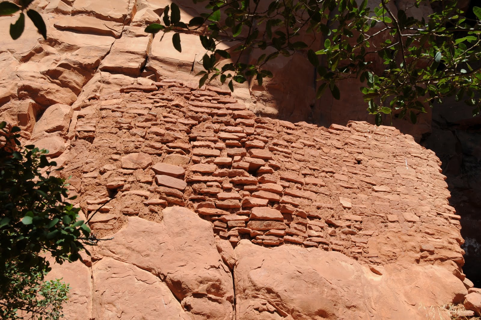
HONANKI HERITAGE SITE Coconino National Forest Our species may have been able to land a man on the moon, but we still haven’t figured out the centuries-old formula for mortar used by Arizona's ancient Sinagua culture. The mighty binder has held up for over 900 years resulting in a remarkably well-preserved collection of cliff dwellings in a remote canyon north of Sedona. A short, mostly shaded dirt path leads to the site which archeologists postulate was home to about 200 people during its heyday. It’s a good idea to either visit the Palatki site first (see blog entry below) or do some independent research before heading to Honanki. That’s because, the rich heritage of this ancient abode runs long and deep and knowing something of the history will enhance your visit. In addition to being expert architects, the people who created Honanki also were masters of earth and sky as evidenced in petroglyphs/pictographs depicting celestial events, and calendars that decorate the wall of the ruins. LENGTH: 0.25 one-way RATING: easy ELEVATION: 4,700 – 4,750 feet BEST SEASONS: September - May DISTANCE FROM PHOENIX: 142 miles one-way GETTING THERE: From the “Y” intersection of Highways 179 and 89A, go left through the traffic circle and head south on 89A (toward Cottonwood). Continue 3.2 miles to Dry Creek Road, turn right and go 2.9 miles to a stop sign, veer left and go 1.6 miles to another stop sign, turn left onto FR152C and go 4 miles to FR525. Turn right on FR525 and go 0.1 miles to a fork in the road, veer left and continue on FR 525 to the parking area. The last 6 miles are rough dirt, a high clearance vehicle is recommended. NOTE: once on Dry Creek Road, it’s easy to follow the signs to “Palatki-Honanki”. HOURS: 10 a.m. to 6 p.m. daily. Closed Thanksgiving and Christmas FEE: A Red Rock Pass ($5 daily per vehicle) or equivalent is required. Call to find out what other passes are accepted. FACILITIES: vault toilet, information kiosk. The site is usually not staffed. INFO: http://www.fs.fed.us/r3/coconino/recreation/red_rock/honanki-ruins.shtml, (928) 282-4119 RESERATIONS: not required. PETS: not allowed NOTE: Please respect the cultural and archeological significance of this fragile site. Do not touch the ruins or art and never pick up or remove any artifact. If you feel compelled, you may call the Forest Service to report a “find”, but please, do not touch!! Also, feel free to photograph any low-lifers (and their license plates) you may see defacing the ruins and forward to the Forest Service.

PALATKI HERITAGE SITE

PALATKI HERITAGE SITE Coconino National Forest For centuries, Native American cultures including the Clovis, Southern Sinagua (ancestors of the Hopi people) and Tonto Apache have inhabited the cliffs of Arizona’s Verde Valley. For most of the 11,000 years that the area around Palatki teemed with life, the climate was much cooler and wetter than it is today and the vast fields in Red Canyon yielded crops of beans, corn and grains. Then came the drought of 1276-1299 and the clans scrambled. Some stayed longer, but eventually, around 1400, the Sinagua abandoned the site. From the mid 15th century until 1875, the Tonto Apache inhabited the cliffs. Then, European settlers showed up with fruit trees. What remains is a rich historical site with some of the best Native American pictographs in the Southwest. Faint images from the Archaic period (11,500 – 8,000 B.C.E. ) mingle with painted flute players and charcoal drawings made by more recent Apache people. The site also features “Willard Cave” where the European settler Charles Willard lived for about a year while building his nearby homestead in the early 1920s. Visitors may enter the cave, provided the resident bats are feeling hospitable. The site has two 0.25-mile trails. One leads to a series of alcoves and the pictographs. The other goes to some cliff dwellings. Forest service guides are very knowledgeable and put on a thoroughly enjoyable tour that lasts roughly 2 hours. On the day we visited, the trail to the dwellings was closed due to rock slide danger and signs posted elsewhere warned that either trail could be closed at any time for safety reasons and/or maintenance, so it’s a good idea to call ahead if you’re hell-bent on seeing everything. LENGTH: 1 mile total (two trails) RATING: easy (some rocky steps) ELEVATION: 4,800 – 4,850 feet BEST SEASONS: September - May DISTANCE FROM PHOENIX: 137 miles one-way GETTING THERE: From the “Y” intersection of Highways 179 and 89A, go left through the traffic circle and head south on 89A (toward Cottonwood). Continue 3.2 miles to Dry Creek Road, turn right and go 2.9 miles to a stop sign, veer left and go 1.6 miles to another stop sign, turn left onto FR152C and go 4 miles to FR525. Turn right on FR525 and go 0.1 miles to a fork in the road, veer right onto FR795 and continue 1.7 miles to the parking area. The last 6 miles are rough dirt, a high clearance vehicle is recommended. NOTE: once on Dry Creek Road, it’s easy to follow the signs to “Palatki”. HOURS: 9:30 a.m. to 3:00 pm daily. The site is closed on Thanksgiving and Christmas and when the access roads are impassable due to snow or storm damage. Call (928) 282-4119 for current conditions. FEE: A Red Rock Pass ($5 daily per vehicle) or equivalent is required. Call to find out what other passes are accepted. FACILITIES: Vault toilet, hand pump for water, visitor center. Forest Service staff stays on site. INFO: http://www.fs.fed.us/r3/coconino/recreation/red_rock/palatki-ruins.shtml RESERVATIONS: Call Palatki at (928) 282-3854 between 9:30 a.m. and 3:00 p.m. to make a reservation. Reservations are highly recommended---without them, you may be turned away at the gate. PETS: not allowed NOTE: Please respect the cultural and archeological significance of this fragile site. Do not touch the ruins or art and never pick up or remove any artifact. If you feel compelled, you may call the Forest Service to report a “find”, but please, do not touch!! Also, feel free to photograph any low-lifers (and their license plates) you may see defacing the ruins and forward to the Forest Service. MORE PHOTOS:http://www.facebook.com/media/set/?set=a.1285662400397.37888.1795269672&type=1&l=2a2cfde131

Thursday, September 23, 2010

NATIONAL-NEWS-RELEASE: Forest Service Begins the Fall Colors Season with 2010 Hotline

From: Press Office Date: September 23, 2010 9:02:52 AM PDT To: USDA-FS-NEWS@newsbox.usda.gov Subject: NATIONAL-NEWS-RELEASE: Forest Service Begins the Fall Colors Season with 2010 Hotline USDA Forest Service Press Release Release No. 1017 Press Office 201 14th St.,SW,Washington, D.C.20024 Voice (202)205.1134 Web: http://www.fs.fed.us Forest Service Begins the Fall Colors Season with 2010 Hotline WASHINGTON, Sept. 23, 2010 - USDA Forest Service officials have turned on the Fall Colors 2010 Hotline - 1-800-354-4595 - and will use Twitter, Facebook and blogging to provide users with the latest information about fall foliage color changes on Forest Service lands. "Thousands of people take trips each autumn on national forests to see the spectacular show of colors," said Tom Tidwell, Chief of the U.S. Forest Service. "Our national forests offer some of the country's best vistas to view fall colors and magnificent landscapes, and they offer an ideal setting for families to get outdoors and learn about trees and changing colors." Changing fall colors also bring positive economic impacts to local economies and the tourism industry. For example, in New England alone, the fall foliage attracts an estimated $8 billion annually to area inns, restaurants, and local shops. Forest Service employees are keeping tabs on the changing hues. The Fall Colors 2010 Web site has links to individual forest fall colors sites and suggestions on how to get kids excited about the season. The site also includes Frequently Asked Questions about why leaves change colors and what happens after the leaves fall. "In the temperate zones, the biggest stresses that trees face are changes of seasons," said Kevin Smith, a Forest Service plant physiologist and an expert on trees. "The fall foliage color change is a milestone during the process of this natural cycle. And trees handle it pretty well." Forest Service officials indicate that general summer weather conditions experienced this year are not expected to influence the timing and intensity of leaf color. What is of particular importance is the timing and frequency of fall frosts. The peak season for fall viewing in most national forests normally begins in late September and continues through early November. However, the specific timing and length of the fall color season is affected by autumn weather patterns that are often difficult to forecast. Consult local forests for best foliage times in your area. The mission of the USDA Forest Service is to sustain the health, diversity, and productivity of the Nation's forests and grasslands to meet the needs of present and future generations. The Agency manages 193 million acres of public land, provides assistance to State and private landowners, and maintains the largest forestry research organization in the world. # NOTE TO EDITORS: To schedule an interview with Kevin Smith, contact the Forest Service Press Office, 202-205-1294. --------------------------------------------------- USDA is an equal opportunity provider, employer and lender. To file a complaint of discrimination, write: USDA, Director, Office of Civil Rights, 1400 Independence Ave., S.W., Washington, D.C. 20250-9410 or call (800) 795-3272 (voice) or (202-720-6382 (TDD).00000000000 - - - - - - - - - - - - - - - - - - - - - - - - - - - - - - - - - - - - - - - To receive official Forest Service information by e-mail, please subscribe by visiting http://www.fs.fed.us/news/subscription/ To unsubscribe from this mailing list, please visit http://www.fs.fed.us/news/subscription If you wish to make changes to an existing account, please visit http://www.fs.fed.us/news/changes.shtml