

 KELSEY WINTER CABIN TRAIL
Kaibab National Forest
KELSEY WINTER CABIN TRAIL
Kaibab National Forest
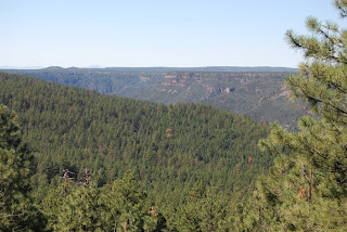
Expansive Sycamore Canyon is Arizona’s second largest gorge. (Guess which one comes in first). Tucked into beautiful pine, juniper and oak forests, Kelsey Winter Trail #3 is the longest of the five trails that criss-cross the central portion of the canyon. It’s also the best way to sample the woodlands, high-chaparral prairies, historic ruins and many flowing springs that make this chasm such an interesting destination. The drive in to the trailhead is half the adventure—the access roads are nasty. Yet, the beauty of this trail makes the kidney-jarring ride worth the effort. From the trailhead, begin hiking downhill along the canyon wall on the Kelsey Spring Trail. Views of Sycamore Canyon along this passage cast an eye-opening spotlight on the magnitude of this “little crack in the earth”. At the half-mile point, the trail meets Kelsey Spring. Here, a short spur trail plows through a wind-swept field of silken grasses for a fun side trip to a trough set up to collect the precious water that seeps from the cliffs. From Kelsey Spring, the trail moves through thick mixed-conifer forests, volcanic boulder fields and open meadows shimmering with vivid purple Wheeler Thistle and blaze-red skyrocket flowers. Babe’s Hole—a spring protected by a funky old cement rim and wood planks—marks the 1.2-mile point just before the junction with Geronimo Spring trail. From here, stay left and continue on the Kelsey Winter Trail--where route finding becomes a challenge. Fallen trees and overgrown vines sometimes obscure the trail past this point. That’s why it’s a good idea to carry a good map and compass when hiking this trail. Once past the obstacles, good signage leads the way to Dorsey Spring, the cabin ruins and yet another spring, which spews fresh cool water year-round.
HIGHLIGHTS: Dense coniferous woodlands, canyon views, several springs and cabin ruins.
LENGTH: 11 miles round-trip
RATING: moderate
ELEVATION: 6,600’ – 6,100’
DOG RATING: 1 paw
Driving distance from Phoenix: 175 miles one-way
GETTING THERE: From Flagstaff, go west on Historic Route 66 to Woody Mountain Road (Forest Road 231). Turn left onto FR 231 and drive 14 miles to Forest Road 538. Turn right onto FR-538 and go 5.7 miles to Forest Road 538E. Turn right onto FR 538E and go another half mile to Forest Road 538G. Continue straight ahead on FR 538G for one mile to Kelsey Trail Road on the left. Because this road is so rough beyond this point, it’s smart to park at the turn off and hike the final quarter-mile to the trailhead. A high clearance vehicle is required.
INFORMATION: (928) 635-8200 or fs.fed.us/r3/kai


 Posts
Posts


 FATMANS LOOP TRAIL
Coconino National Forest
Named for a narrow rock passage on the foothills of lava dome volcano, the Fatmans Loop #25 is one of the most popular hiking trails in Flagstaff. A great destination for kids because of its short length and continually changing points of interest, the route gives the feeling of being “out there” without cutting the umbilical cord to civilization. The highlight of the hike is Fatmans Pass, where hikers must shimmy through a set of narrow boulder passages in the shadow of Elden Mountain. Because of the easy-to-follow path, terrific vista views, and lots of cool shade, the fact that the “golden arches” are visible on the horizon doesn’t sully the experience in the least.
HIGHLIGHTS: Close-to-town, easy-to-follow and great views of Flagstaff.
LENGTH: 2-mile loop
RATING: easy
ELEVATION: 6,900’ – 7,500’
Driving distance from Phoenix: 150 miles one-way
GETTING THERE:
From Flagstaff, travel north on AZ89 to the signed “Mt. Elden Trailhead” which is located just past milepost 419.
Information: (928) 526-0866 or fs.fed.us/r3/Coconino
FATMANS LOOP TRAIL
Coconino National Forest
Named for a narrow rock passage on the foothills of lava dome volcano, the Fatmans Loop #25 is one of the most popular hiking trails in Flagstaff. A great destination for kids because of its short length and continually changing points of interest, the route gives the feeling of being “out there” without cutting the umbilical cord to civilization. The highlight of the hike is Fatmans Pass, where hikers must shimmy through a set of narrow boulder passages in the shadow of Elden Mountain. Because of the easy-to-follow path, terrific vista views, and lots of cool shade, the fact that the “golden arches” are visible on the horizon doesn’t sully the experience in the least.
HIGHLIGHTS: Close-to-town, easy-to-follow and great views of Flagstaff.
LENGTH: 2-mile loop
RATING: easy
ELEVATION: 6,900’ – 7,500’
Driving distance from Phoenix: 150 miles one-way
GETTING THERE:
From Flagstaff, travel north on AZ89 to the signed “Mt. Elden Trailhead” which is located just past milepost 419.
Information: (928) 526-0866 or fs.fed.us/r3/Coconino


